
Erongo
|
||||
| Basic data | ||||
|---|---|---|---|---|
| Regional capital | Swakopmund | |||
| Biggest town | Walvis Bay | |||
| motto | Industry, Cooperation, Integrity (industry, cooperation, integrity) |
|||
| ISO 3166-2 | NA-ER | |||
| website | www.erc.com.na | |||
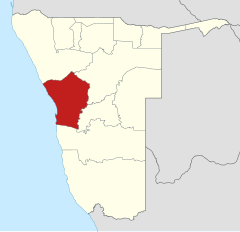
| Map of the region | ||||
  |
||||
| Inhabitants and geography | ||||
| population | 182,402 (as of 2016) | |||
| Population density | 2.86 per km² | |||
| languages | Afrikaans , German , English , Khoekhoegowab | |||
| Geographic coordinates | 22 ° 35 ′ S , 15 ° 7 ′ E | |||
| surface | 63,719 km² | |||
| The highest point | 2,573 m ( Königstein ) | |||
| Politics and administration | ||||
| Ruling party | SWAPO | |||
| Governor / in | Neville Andre | |||
| Distribution of seats in the regional council | SWAPO 6, UDF 1 | |||
| Constituencies | 7th | |||
| Last choice | 2015 | |||
| Next choice | 2020 | |||

Erongo is one of the 14 regions of Namibia and forms the most populous stretch of coast of Namibia on the Atlantic Ocean with Swakopmund as the regional capital and Walvis Bay as the country 's largest overseas port . The coastal sections north and south of this agglomeration are essentially just desert . Inland there are also important mines in Erongo. The name Erongo is derived from the Erongo Mountains .
geography
→ See also: Geography of Namibia

An essential part of Erongo is the area on the South Atlantic coast, which became known as the Skeleton Coast , because many ships were stranded there due to the offshore shallows and could no longer be made afloat. The entire area of this skeleton coast is completely dry except for a few small rivers that rarely carry water. Survival there is almost impossible for visitors or shipwrecked people. For some years now, a wide road (pad) has been running parallel to the coast until just before the Angolan border , but from the gate of the Skeleton Coast Park it is only allowed to drive with a special permit, which is issued at the ranger station in Swakopmund . The Government Camp Terracebay is the only station in the Skeleton Coast Park. Slowly increasing populations of elephants immigrating from the Etosha National Park through the Kowarib Gorge and over the Grootberg Pass along the Hoanib to the coastal Namib and, more rarely, predators , e . B. the brown hyena, also known as the beach wolf or saddleback hyena , form, in addition to the vastness and tranquility, the goal of a special tourism off the beaten track. A cul-de-sac in the direction of the Etosha Pan , past the Petrified Forest , is the only man-made change.
Further south, just before Swakopmund, there is the Robbenkap where large Robben - populations are observed throughout the year because of vorbeiführende here cold Benguela current can pass in abundance of fish. Even trawlers from many countries that can be observed at night , far beyond the sandbanks, indicate that sufficient fish resources are still available .
population
According to the 2011 census , 38.8 percent of the Oshivambo area's residents speak their primary language. This is followed by Afrikaans with 20.4 percent, Khoekhoegowab with 18.8 and Otjiherero with 9.6 percent. 2.8 percent of the population use German as their main language.
Regional policy
Since 2004, SWAPO has provided the absolute majority of the seven Erongo regional council members who are elected to the regional capital Swakopmund every five years.
| Political party | 1992-1997 | 1998-2004 | 2004-2010 | 2010-2015 | 2015-2020 |
|---|---|---|---|---|---|
| SWAPO | 3 | 2 | 5 | 7th | 6 (4) |
| DTA (PDM) | 2 | 4th | 0 | 0 | 0 (1) |
| UDF | 1 | 0 | 2 | 0 | 1 |
| RP | 1 | 1 | 0 | 0 | 0 |
| Independently | 0 | 0 | 0 | 0 | 1 |
| The number of seats can change through by-elections in the course of a legislative period. | |||||
Administrative division
.svg)
182,402 inhabitants (as of 2016) in seven constituencies live in an area of 63,719 square kilometers .
- Arandis - SWAPO
- Daures - UDF
- Karibib - SWAPO
- Omaruru - SWAPO
- Swakopmund - SWAPO
- Walvis Bay Land - SWAPO
- Walvis Bay City - SWAPO
In addition, the following local administrations can be found in the region (as of June 2018):
- Arandis - city
- Henties Bay Parish
- Karibib parish
- Omaruru Church
- Otjimbingwe - settlement
- Usakos - parish
- Swakopmund - municipality
- Walvis Bay - borough
economy
After the Khomas region, the Erongo region is the most economically powerful in Namibia. The port of Walvis Bay and the numerous mining areas such as the Rössing and Husab mines are primarily responsible for this. In addition, the largest stone processing company in Africa is located on the outskirts of Walvis Bay.
One of the largest current economic projects (as of May 2018) is the construction of a seawater desalination plant near Wlotzkasbaken , which is to bring fresh water over 300 kilometers for irrigation agriculture to Omaruru . In addition, a university hospital is being built in Arandis and a fuel depot near Usakos.
Web links
Individual evidence
- ↑ a b Namibia Inter-censal Demographic Survey 2016 Report. Namibia Statistics Agency, November 21, 2017.
- ↑ 2011 Population and Housing Census Regional Profile, Erongo Region. Namibia Statistics Agency, p. 41f. Retrieved June 10, 2020.
- ↑ Contact Us. Erongo Regional Council. Retrieved June 1, 2018.
- ↑ Gigantic factory presented in the Namib. In: Allgemeine Zeitung , July 14, 2014, accessed on November 16, 2014
- ^ Morning news. Hitradio Namibia, May 11, 2018.