Grandmaheke
|
||||
| Basic data | ||||
|---|---|---|---|---|
| Regional capital | Gobabis | |||
| Biggest town | Gobabis | |||
| motto | ||||
| ISO 3166-2 | NA-OH | |||
| website | www.omahekerc.gov.na | |||
| Map of the region | ||||
| Inhabitants and geography | ||||
| population | 74,629 (2016) | |||
| Population density | 0.88 per km² | |||
| languages | Afrikaans , Khoekhoegowab , Otjiherero | |||
| Geographic coordinates | 22 ° 2 ′ S , 19 ° 26 ′ E | |||
| surface | 84,731 km² | |||
| The highest point | 1874 meters ( Okambaraberg ) | |||
| Politics and administration | ||||
| Ruling party | SWAPO | |||
| Governor / in | Pijoo Nganate | |||
| Distribution of seats in the regional council | SWAPO 4, NUDO 2, Independent 1 | |||
| Constituencies | 7th | |||
| Last choice | 2015 | |||
| Next choice | 2020 | |||
Omaheke is one of the 14 regions of Namibia and the home of the Herero . Omaheke has an area of 84,731 square kilometers (slightly larger than Austria ) with a population of 74,629 inhabitants (as of 2016). It is the fifth largest and least populous region in Namibia.

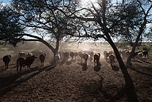
The Omaheke region, Otjiherero for " Sandveld ", is essentially characterized by the foothills of the Omaheke , a landscape area of the Kalahari . Savannas , acacias and camel thorn trees determine the picture.
history
During the Herero uprising in what was then German South West Africa in 1904, after the Battle of Waterberg , the defeated Herero attempted to retreat through the Omaheke to Bechuanaland , today's Botswana , which was planned for this case and agreed with the British protectorate . The German colonial power instructed its troops to pursue the fugitives and they “[…] repeatedly from event. to chase away water holes found there [...] ”. A large part of the refugees died of thirst in the Omaheke. The approach of the German colonial power is considered by science to be the first genocide of the 20th century. Those who reached the goal returned to their tribal areas after the repeal of the so-called extermination order became known.
population
According to the 2011 census , 41.5 percent of the inhabitants of the Otjiherero region speak the main language. It is followed by Khoekhoegowab with 28.1 percent and Afrikaans with 10 percent. 0.4 percent of the population use German as their main language.
Regional policy
Since the regional council elections in 2015 , SWAPO has held the majority in the regional council.
Administrative division
In addition, there are (as of December 2015) four local administrations and seven settlements in the region:
- Gobabis - municipality / city
- Leonardville - village
- Otjinene - village
- Witvlei - village
- Aminuis - settlement
- Buitepos - settlement
- Corridor 13 - settlement
- Epukiro - settlement
- Omitara - settlement
- Summerdown settlement
- Talismanus - settlement
economy

The majority of the land is used by the approximately 800 large farms that mainly raise cattle here.
Web links
Individual evidence
- ↑ Namibia Inter-censal Demographic Survey 2016 Report. Namibia Statistics Agency, November 21, 2017.
- ↑ Dominik J. Schaller: »I believe that the nation as such must be destroyed: Colonial war and genocide in« German South West Africa »1904–1907« . In: Journal of Genocide Research . Volume 6: 3 (2004), p. 397
- ^ Jürgen Zimmerer and Joachim Zeller (eds.): Genocide in German South West Africa. The colonial war (1904–1908) in Namibia and its consequences. Links Verlag, Berlin 2003, ISBN 3-86153-303-0 .
- ^ Tilman Dedering: The German-Herero War of 1904: Revisionism of Genocide or Imaginary Historiography? In: Journal of Southern African Studies . Volume 19, No. 1, 1993, p. 80
- ↑ Dominik J. Schaller: »I believe that the nation as such must be destroyed: Colonial war and genocide in« German South West Africa »1904–1907« . In: Journal of Genocide Research . 6: 3, p. 395
- ↑ Reinhart Kößler , Henning Melber : Genocide and Remembrance. The genocide of the Herero and Nama in German South West Africa 1904–1908 . In: Irmtrud Wojak and Susanne Meinl (eds.): Genocide. Genocide and War Crimes in the First Half of the 20th Century . Frankfurt am Main, Campus, 2004, pp. 37–76 (= yearbook on the history and effects of the Holocaust 8)
- ↑ Medardus Brehl: "These blacks deserve death before God and people" The genocide of the Herero in 1904 and its contemporary legitimation . In: Irmtrud Wojak and Susanne Meinl (eds.): Genocide. Genocide and War Crimes in the First Half of the 20th Century . Campus, Frankfurt am Main 2004, pp. 77–97 (= yearbook on the history and effects of the Holocaust 8)
- ↑ George Steinmetz: From “Native Policy” to the Extermination Strategy: German South West Africa, 1904 . In: Peripherie: Journal for Politics and Economics in the Third World . Volume 97–98, 2005, p. 195 Article Online in Open Access
- ↑ Jörg Wassink: On the trail of the German genocide in South West Africa. The Herero / Nam uprising in German colonial literature. A literary historical analysis. M.Press, 2004, ISBN 3-89975-484-0 .
- ↑ Mihran Dabag , Horst Gründer and Uwe-Karsten Ketelsen: Colonialism, Colonial Discourse and Genocide. Fink Verlag, 2004, ISBN 3-7705-4070-0 .
- ↑ 2011 Population and Housing Census Regional Profile, Omaheke Region. Namibia Statistics Agency, p. 44f. Retrieved June 10, 2020.
- ↑ Official election result of the regional and local elections 2015, ECN, December 4, 2015 ( Memento of the original of December 10, 2015 in the Internet Archive ) Info: The archive link was inserted automatically and has not yet been checked. Please check the original and archive link according to the instructions and then remove this notice. (PDF; 150 kB)
- ^ Settlements. Omaheke Regional Council. Retrieved April 16, 2019.


