
Caribib
| local community Caribib Otjandjomboimwe ( her ) Kharibes ( khi ) |
|||
|---|---|---|---|
|
|||
 |
|||
| motto | |||
| Basic data | |||
|
Population Area Population Density |
5132 (2011 census) 103.6 km² 49.5 inhabitants / km² |
||
|
State Region Constituency |
Namibia Erongo Karibib |
||
| Establishment date | July 11, 1894 | ||
|
License plate phone code |
KR 64 |
||
| Website | karibibtown.org | ||
.svg) |
|||
|
Political data
Mayor : Petrus Nabot ( SWAPO ) Chief Executive Officer : {{{CEO}}} Last election: 2015 Next election: 2020 City administration address: |
|||
|
Geographical data
Geographic coordinates : 21 ° 56′16 "S, 15 ° 51′16" E Height : 1,193 m |
|||


Karibib is a municipality in the Karibib constituency of the same name in the Erongo region in western Namibia . Karibib is located on the B2 national road between the coastal town of Swakopmund and the Namibian capital Windhoek . In 2011 it had 5132 inhabitants.
The headquarters of the Namibian Air Force is located in Karibib .
history


The later place Karibib arose at a water place which the Herero called Otjandjomboimwe. The merchant Eduard Hälbich Junior, a son of the merchant and wagon maker Eduard Hälbich in Otjimbingwe , bought the water point and 20,000 hectares of land from Herero captain Zacharias Zeraeua in 1894/95 . The purchase price was 22,500 Reichsmarks, two ox wagons with oxen and 742 pounds and five shillings. Part of the purchase price was offset against the debts that Zeraeua had in the Hälbich shop.
Hälbich also opened a shop in Karibib around 1897. The settlement developed quickly, especially when the newly built railway from Swakopmund reached the place on May 30, 1900. On June 1st of the same year the Swakopmund – Windhoek railway was officially opened. This date is considered to be the founding date of Karibib. The train station, a doctor's office, a prison, warehouses and residential buildings are built. In 1899 a second water hole was created in Karibib.
On July 1, 1901, Karibib broke away from the district administration in Omaruru , and on December 1, 1901, the central administration of the protected area of Otjimbingwe moved to Karibib. In 1902 the railway line was extended to Windhoek. From 1904, Karibib played an important role as a railway junction for troop transports and as a military base in the Herero and Nama Wars. The white settlers of Karibib are rarely bothered because of the benevolence of Zacharias Zeraeuas. On February 2, 1904, District Governor Captain Victor Franke and his troops reached Karibib and drove the plundering insurgents towards Okahandja .
In 1907 Karibib already had 316 white residents. With the end of the war in 1907, the rest of the Herero's land was expropriated and offered to white farmers. In 1909 Karibib municipality and Eduard Hälbich became mayor.
In 1973, Karibib gave its name to the newly discovered mineral caribibite near the community .
economy


The largest employer in the city is the Navachab gold mine owned by Anglogold Ashanti near Karibib.
Karibib marble quarrying
The place is known worldwide for the marble, which is valued for its precious quality and quarried here . Some of these are pure calcitic and sometimes also strongly dolomitic marble varieties. Their colors vary greatly. There are tints of pure white, gray, ivory, blue-gray, white and black veined or striped. Furthermore, color nuances occur due to the accessory mineral content in green, yellow, red and pink. Brecciated, brightly colored or red and yellow flamed varieties were in particular commercial demand . Their textural properties gave them names after European varieties, such as Cipollino , Pavonazzo , Bardiglio and the like. a. The mining sites are located in the area around Karibib and extend to the area of the Navachab, Habis and Etusis farms (southwest of Karibib). Their marble layers lie between granites and quartzites and extend up to 20 kilometers on strike .
Solar power plant
Karibib has had a solar power plant since June 9, 2017 . It is 2 km southwest of the train station outside the city.![]()
Karibib military airfield
North of the city is a military airfield built by the South African Air Force ( Karibib Airport ). It has been the headquarters of the Namibian Air Force again since March 4, 2016 .
Worth seeing


The town of Karibib has some buildings of historical interest (see: List of National Monuments in Namibia ), including a mission church from 1894.
The tourism industry was also an integral part of the city for a long time, which is why there were numerous hotels such as the “Erongoblick”, the “Stroblhof” or the “Albrechtshöhe”. The German “Pub 1913” directly on the main street was also particularly well-known.
Other historical sights of the city are for example
- the Kaiserbrunnen, built 1906–1908,
- the "Hälbich Branch", an industrial area that already existed in colonial times,
- the "Roesemann building" from 1900,
- the "Woll-Haus", which was built in 1900 from the famous Karibiber marble,
- as well as the hotel "Zum Grünen Kranze" from 1913.
Local politics
The following official final result was determined in the 2015 local elections .
| Political party | be right | Share of votes | Seats |
|---|---|---|---|
| SWAPO | 653 | 61.3% | 4th |
| UDF | 223 | 20.9% | 2 |
| Karibib Residents Association | 128 | 12.0% | 1 |
| RDP | 38 | 3.6% | 0 |
| RP | 23 | 2.2% | 0 |
| All in all | 1065 | 100% | 7th |
Town twinning
Educational institutions
- Da-Palm Junior Secondary School
- Ebenhaeser Primary School
- Karibib Junior Secondary School
- Karibib Private School
gallery

Karibib during the German colonial era , around 1910
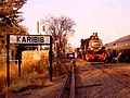
Caribiber train station

“Pub 1913” in Karibib

Karibib solar power plant (2017)


Web links
- Official website (English)
Individual evidence
- ↑ 2011 Population and Housing Census, Erongo Regional Profile. ( Memento of the original from September 6, 2014 in the Internet Archive ) Info: The archive link was inserted automatically and has not yet been checked. Please check the original and archive link according to the instructions and then remove this notice. Namibia Statistics Agency , 2014, p. Ii
- ↑ Wolfgang Henckert: Karibib. (No longer available online.) Henckert Tourist Center, archived from the original on July 11, 2011 ; Retrieved March 16, 2006 . Info: The archive link was inserted automatically and has not yet been checked. Please check the original and archive link according to the instructions and then remove this notice.
- ↑ http://www.namibian.org/travel/namibia/karibib.html
- ↑ C. Gagel: German Colonies . In: C. Gäbert, A. Steuer, Karl Weiss (Hrsg.): The usable rock deposits in Germany . Berlin 1915, pp. 406-407
- ^ Federal Institute for Geosciences and Raw Materials, Angela Ehling: 04/04: Marble from Namibia. The collection item of the month . on www.bgr.bund.de
- ↑ Air Force headquarters relocate to Karibib. Namibia Press Agency, March 6, 2016
- ↑ Local Authorities 2015. The Namibian, December 4, 2015, pp. 6ff
- ↑ SOWA join forces with Namibian town. The Voice, April 20, 2018.
Coordinates: 21 ° 56 ′ S , 15 ° 51 ′ E