
Swakopmund
| Municipality and constituency Swakopmund Tsoakhaub ( naq ) Otjozondjii ( her ) |
|||
|---|---|---|---|
|
|||
 |
|||
| motto | Providentiae memor ( Mindful of Providence) |
||
| Basic data | |||
|
Population Area Population Density |
44,725 ( 2011 census ) 196.3 km² 227.84 inhabitants / km² |
||
|
State Region Constituency |
Namibia Erongo Swakopmund |
||
| Establishment date | 4th August 1892 | ||
|
License plate phone code |
S (0) 64 |
||
| Website | swakopmun.com | ||
.svg) |
|||
|
Political data
Mayor : Paulina Nashilundo ( SWAPO ) list Chief Executive Officer : Eckart Demasius Last election: 2015 Next election: 2020 City administration address: |
|||
|
Geographical data
Geographic coordinates : 22.67 ° S, 14.52 ° E Height : 5.7 m |
|||


Swakopmund is a municipality , a constituency and capital of the Erongo region in western Namibia . The city has 44,725 inhabitants and is located in the Namib , directly on the Atlantic Ocean near the mouth of the Swakop River . The city has an area of 196 square kilometers . According to the request of the city administration, this should be expanded to 1,435 square kilometers from June 2014.
geography
Geographical location
Swakopmund lies on a flat section of the Namibian south Atlantic coast , directly north of the mouth of the Swakop River . The city is bounded from the north and east by the sandy desert of the Namib and the Skeleton Coast , which means that there is very little rainfall in the region. The closest higher elevations are the Rössingberge , around 20 kilometers inland.
climate
The mild coastal climate makes the city a popular excursion destination and seaside resort on the South Atlantic, especially during the months of October to March , even if the coastal fringe is mostly foggy in the mornings as a result of the cold Benguela current coming from the Antarctic and the water temperature hardly rises above 20 ° C.
|
Monthly average temperatures and rainfall for Swakopmund / Walvis Bay
Source:
|
|||||||||||||||||||||||||||||||||||||||||||||||||||||||||||||||||||||||||||||||||||||||||||||||||||||||||||||||||||||||||||||||||||||||||||||||||||||||||||||||||||||
history


The city gained historical importance under the German colonial administration as part of the colony of German South West Africa and as the most important port for immigrants from Germany . Lüderitz was too far away from the roads inland and the more suitable natural harbor of Walvis Bay was under British administration. However, the British had threatened in 1889 that they would no longer allow German troops to march through their territory.
The Swakop was discovered by HMS Espiègle in 1824. Lieutenant Ruxton examined the river in 1845 and found, among other things, that water flows beneath the surface even when it is dry.
In 1885 the gunboat Wolf put a flagstick and a plaque with the inscription “Vom 26. ° s.Br. up to 18 ° s.Br. with the exclusion of the Walvis Bay area under the protectorate of the German Reich. ”The commander of the gunboat Habicht had great difficulties when going ashore in April 1886 south of the mouth of the Swakop. On the other hand, the captain of a Woermann steamer found favorable conditions north of the estuary when he went ashore in late 1889.
Curt von François first looked for a landing site on a patrol ride from September 27 to October 6, 1889 in the area of the Swakop estuary. The German ship Falke erected a beacon here in August 1892 . According to his own statements, Curt von François stayed in Swakopmund from September 2 to October 2, 1892 and had a station building for 20 men and a 20 meter long storage room built near the beacon. During his visit in November 1892 he took the first test drives and identified two places suitable for landing. On January 26, 1892, the cruiser Falke came again , this time in a landing craft, and found a spot suitable for the port.
In March 1893, 225 soldiers landed here for the first time, under adventurous and life-threatening circumstances, as reinforcement for the until then numerically smaller protection force . Only two of them died a few weeks later in the first battle of the colonial power in German South West Africa, the Hornkranz massacre , when François raided the residence of the Nama leader Hendrik Wittbooi , killing at least 80 people.


The Germans built an artificial harbor (mole), which was very costly, in order to be able to bring in supplies for the interior from the sea. An imperial port construction authority was set up, which kept the port usable with the ship Pionier and the dredger Bagger III . In 1902 the construction of a lighthouse and a jetty began. The pier was initially made of wood. In 1912 it was rebuilt from iron. Today it is called Jetty by the Swakopmundern .
The Hamburg shipping company Woermann began regular freight traffic in 1894. In the following years everything that was needed by the German colony of German South West Africa was imported via Swakopmund. On April 13, 1899, the first telegraph service was opened in international service. From then on the construction of extensive telegraph lines in the colony began. On June 20 and July 1, 1902, the first German-South West African railway was opened from Swakopmund to Windhoek through the 100 km wide sandy desert there (382 km long; rising to 1637 m above sea level). The construction of the tracks and stations in Swakopmund and Windhoek had been started by railway troops from the German Reich .
In 1907 the German politician Wilhelm Külz came to Swakopmund to introduce local self-government in the colony . In 1909, Swakopmund was finally granted town charter and on February 4, 1912, finally a coastal radio station .
On September 23 and 24 and on October 30, 1914, Swakopmund was shelled by British auxiliary cruisers . With the occupation by South African troops in 1914, the German protected area became a secondary theater of the First World War for two years , in 1919 a mandate area of the League of Nations and placed under the administration of the South African Union .
After the country gained independence in 1990, Swakopmund's local council changed many of the original German and Afrikaans street names to names that mainly remember black Namibians.
In July 2009 the city administration changed the coat of arms of Swakopmund after almost 37 years . The black-white-red German imperial flag shown in the heart shield was replaced by the coat of arms of Namibia . In addition, the Dreidorn was replaced by a Welwitschia .
population
Although only about five percent of the population are of German descent, their influence on city life is evident. To this day, Swakopmund is considered to be the “most German” city in Namibia, something which the renaming of a number of the originally German street names to “contemporary African” has changed little. The unique mixture of German-influenced seaside resort, African population and impressive dune landscape make Swakopmund a popular destination for group travelers and individual tourists. Residents of the capital Windhoek also like to flee here during the great heat in summer, which is also evidenced by the brisk construction activity that Swakopmund has expanded to the north in recent years.
politics
Municipal council
The municipality of Swakopmund is located in the Swakopmund City Administration building .
The following official final result was determined in the 2015 local elections .
| Political party | be right | Share of votes | Seats |
|---|---|---|---|
| SWAPO | 5534 | 62.3% | 6th |
| UDF | 1168 | 13.2% | 1 |
| Swakopmund Residents Association (SRA) | 790 | 8.9% | 1 |
| DTA | 497 | 5.6% | 1 |
| NUDO | 296 | 3.3% | 1 |
| RDP | 189 | 2.1% | 0 |
| CDVP | 133 | 1.5% | 0 |
| APP | 126 | 1.4% | 0 |
| SWANU | 83 | 0.9% | 0 |
| RP | 63 | 0.7% | 0 |
| All in all | 8879 | 100% | 10 |
Administrative division
Districts or suburbs of Swakopmund are:
- Mile 4
- Mondesa
- Tamariskia
- Kramersdorf with dunes
- Vineta
- Bird beach
- Waterfront
- Central
Most of the city's citizens live outside the city center in the suburbs of Vineta, Tamariskia, Mondesa, and Vogelstrand. Well-to-do White and Black Namibians live in Vineta, Tamariskia is the colored quarter and Mondesa is the quarter for Black Namibians originally founded in 1960 as an apartheid reserve. Kramersdorf and residential areas directly on the Atlantic to the north are mainly inhabited by the wealthy.
Town twinning
Source among others:
-
 Florianópolis
-
 KwaDukuza (since 2013)
-
 Malmo
Malmo
-
 Okakarara (since 2007)
-
Oranjemund (since 2017)
-
 Sharm El Sheikh
-
 Tianjin
-
Walvis Bay
-
Yiwu
Culture and sights
.jpg)

.jpg)
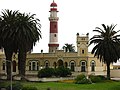
The Swakopmund Museum shows exhibits on archeology , mineralogy , botany , prehistory and early history and German colonial history. There is also an exhibition about the people of Namibia. Not far away is the Swakopmund lighthouse, the city's landmark.
Bathing in the nearby South Atlantic is possible, but only recommended for particularly tough athletes, as the cold Benguela current ensures that the water temperatures rarely exceed 15 ° C. Nevertheless, older people can be found daily in the morning bath in sometimes impressive waves.
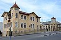
Other special sights a short distance from the beach are the " marine monument ", the old prison , the old district court (1906), the former district court and today's summer residence of the Namibian president, the crystal gallery (a newly built mineral museum), the shopping arcade at the Nujoma-Allee, the Hohenzollernhaus , the pioneer barracks from 1905 and the former military hospital on the street of the same name, the Woermannhaus and the old train station from 1901, a functional building also built by the German protection force in the style of the time, but which was converted into a luxury hotel and is now the center of a casino and entertainment complex. Another historically interesting building is the "Ritterburg", which was named after Theodor Ritter . From here he managed the Woermann Line's business between 1905 and 1908 . The knight's castle, then ideally located on a high dune near the landing stage, gave a good overview of the open Atlantic coast. For many years, the knight's castle was a student residence ; today (as of July 2018) the offices of the nature conservation authority are housed here. The center is also home to the National Maritime Aquarium of Namibia and the Living Desert Snake Park .
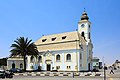
The church , built in 1911, and the rectory of the German Lutheran Congregation in neo-baroque style are also worth seeing . Services are held there on Sundays in German.
An old locomobile is on the eastern edge of the city, near the B2 national road . It was intended to bring supplies inland. Due to a lack of water and probably also due to technical problems, the locomobile stopped on the outskirts. That earned him the name Martin Luther , as he is said to have said to Worms at the Reichstag : "Here I stand, I can't help it." The locomobile is no longer in the open air as it used to be, but after the restoration in a specially built hall.
With The Dome , Swakopmund has the largest sports and event hall in Namibia.
Attractions in the area
.jpg)
- Welwitschiaroute
- Rössing mine , the largest uranium mine in the world. It is located on the B2 national road , about 70 kilometers east of Swakopmund.
- Henties Bay
- Lunar landscape in the Swakoptal
- Namib Desert
- Goanikontes oasis
- Sandwich Harbor
- Vogelfederberg , a 60 meter high island mountain , about 50 kilometers east of Walvis Bay on the main road C14
- Walvis Bay
Economy and Infrastructure
economy

Swakopmund is a tourist destination and has a busy main season, especially during the summer months of December and January. The tourism sector and the associated trade is probably the most important branch of Swakopmund's economy, fed not only by the numerous tourists, especially from Europe, but also by the inner-Namibian tourism and the fact that Swakopmund, thanks to its favorable climatic conditions, is a preferred refuge for many Namibian or South African retirees. The Strand Hotel was supposed to open as a five-star hotel in 2011 , but construction was postponed until further notice. Along with the Swakopmund Hotel and Hansa Hotel, it would be one of the city's luxury hotels .
The city's budget for the 2011/2012 financial year is Namibian dollars 267.7 million .
In August 2012 the Namibian government provided a 700 hectare area between Wlotzkasbaken and Swakopmund for the construction of an industrial park planned by the Gecko Namibia Group since April 2011 . A chemical plant is to be built there, which will then supply the region's mining industry with chemicals . In addition, a small power plant and a seawater desalination plant to supply electricity and water to the mining industry are to be built there. Because Gecko Namibia is also planning to remove phosphate from the seabed in the future , critical voices regarding the planned industrial park have accumulated, so that the project can only be implemented once a positive environmental impact study is available. According to experts, this could take several years.
In 1968 what was then Hansa Brewery was taken over by South West Breweries, now Namibia Breweries .
traffic
Swakopmund is connected to Windhoek via the well-developed, asphalted national road B2 , which forms part of the Trans-Kalahari Highway starting in Walvis Bay and leading to Johannesburg in South Africa , and to the neighboring port city of Walvis Bay via the Swakop Bridge .
The Swakopmund airport has no regular line air traffic for more. For regional flight connections and South Africa, you have to switch to Walvis Bay Airport , which is not connected to Swakopmund by public transport.
Swakopmund station on the Swakopmund – Windhoek railway line has been in operation since 1902 . The railway line begins today in Walvis Bay and, like the entire Namibian railway network, is based on the Cape gauge (gauge 1,067 mm). A freight train runs once a day , which also carries passenger cars four times a week. The so-called Desert Express , a luxury train serving tourist purposes , runs at irregular intervals and especially when required . a. also in the capital.
education
.jpg)
State schools
- Atlantic Primary School
- Coastal High School
- Festus Gonteb Junior Primary School
- Hanganeni Primary School
- Namib High School (until 1997 German Oberschule Swakopmund) - founded in 1913
- Namib Primary School (until 1997 German Primary School Swakopmund) - founded in 1913
- Swakopmund Primary School
- Swakopmund Secondary School
- Tamariskia Primary School
- Vrede Rede Primary School
- Westside High School
Private schools
- Swakopmund private school
- Pro-Ed Academy
- Riverside Private School (Swakopmund School of Excellence)
- Swakopmund Christian Academy
In Swakopmund there is the Private German Schoolchildren's Home Swakopmund , which will act as accommodation for students mainly from the two former German schools until 2018. It was operated by the German School Association Swakopmund .
sons and daughters of the town
- Werner Schulz (1913–1947), national soccer player
- Eberhard Kulenkampff (* 1927), architect, town planner and artist
- Kosie Pretorius (1935-2017), politician (MAG)
- Joachim Zeller (* 1958), historian and teacher
- Bernhard Esau (* 1957), Namibian Minister
- Burgert Brand (* 1959), clergyman and bishop of the Evangelical Lutheran Church in Namibia
- Martin Baumann (* 1960), religious scholar
- Martin Debus (* 1966), theater director and actor
- Razundara Tjikuzu (* 1979), former soccer player for Werder Bremen , Hansa Rostock and MSV Duisburg
- Paulus "The Rock" Ambunda (* 1980), professional boxer
- T-Zon (* 1993 as Christoph Albrecht Paul Thesen), rap and pop musician
gallery
Lighthouse & State House
Evangelical Lutheran Church

Former train station, today Swakopmund Hotel

The old district court
Knight's castle , behind it the former Hotel Fürst Bismarck

Memorial Marine Expeditionary Corps by Albert Moritz Wolff
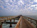
"Jetty" in Swakopmund


.jpg)
.jpg)


literature
- Conny von Dewitz: Swakopmund. The little city guide . Kuiseb, Windhoek 2009, ISBN 978-3-941602-34-2 .
- Chris Malitela: Historic buildings rediscovered in Swakopmund . Oasys Namibia, Swakopmund 2000, OCLC 174817657 .
- WGS: Swakopmund - A small chronicle . Scientific Society Swakopmund, Swakopmund 2006, ISBN 3-936858-62-4 .
- Christine Marais: Swakopmund - our legacy . Gamsberg Macmilla, Swakopmund 1996, ISBN 0-86848-051-7 .
- Ruth Winkler: place of birth Swakopmund . Kuiseb, Windhoek 1993, ISBN 99916-703-1-9 .
Web links
- Official website (English)
- Swakopmund Structural Plan 2020–2040 (PDF; English)
Individual evidence
- ↑ 2011 Population and Housing Census Main Report . Namibia Statistics Agency, p. 39 , accessed on September 16, 2017.
- ↑ Namibia 2011 Population and Housing Census Preliminary Results. Namibia Statistics Agency, April 2012 , accessed May 9, 2012.
- ↑ Swakopmund swallows Wlotzkas. Allgemeine Zeitung, June 3, 2014 , accessed June 3, 2014.
- ↑ MSN Weather Swakopmund, Namibia. MSN Weather, accessed September 10, 2009 .
- ↑ Climate Swakopmund - Namibia. Climatedata.eu, accessed on September 1, 2010 (English).
- ^ Curt von François : German South West Africa. History of colonization up to the outbreak of war with Witbooi. Reimer, Berlin 1899, p. 51 Digitized version accessed on November 15, 2018
- ^ From the River Cameroon to the Cape of Good Hope. (= African pilot. Part II ). 2nd Edition. Hydrographic Office, London 1875. p. 190 Digitized version accessed on 15 November 2018
- ^ Curt von François: German South West Africa. History of colonization up to the outbreak of war with Witbooi. Reimer, Berlin 1899, p. 53 Digitized version accessed on November 15, 2018
- ^ Curt von François: German South West Africa. History of colonization up to the outbreak of war with Witbooi. Reimer, Berlin 1899, p. 52 Digitized version accessed on November 15, 2018
- ^ Curt von François: German South West Africa. History of colonization up to the outbreak of war with Witbooi. Reimer, Berlin 1899, p. 157 Digitized version accessed on November 15, 2018
- ^ Maggi Barnard: Namibia: Minister Urges Swakopmund Residents to Accept Change . In: AllAfrica . December 12, 2002.
- ^ AZ Online: New City Coat of Arms , July 30, 2009.
- ↑ Local Authorities 2015. The Namibian, December 4, 2015, pp. 6ff
- ↑ Swakopmund Lightbeams, newsletter of the city administration Swakopmund: SISTER CITIES & TOWNS , p. 6, July 2008 ( Memento from December 27, 2016 in the Internet Archive ) (PDF; 940 kB)
- ^ New town twinning with KwaDukuza. Allgemeine Zeitung, March 13, 2014 , accessed on March 14, 2014.
- ^ Cooperation Agreement with Okakarara Town Council, Swakopmund Municipality, 2007
- ↑ Swakopmund Our Legacy , accessed July 22, 2018.
- ↑ COUNCIL APPROVES BUDGET OF N $ 267.7 MILLION, Swakopmund City Council, June 2011
- ↑ Allgemeine Zeitung (Namibia, 2012) - EIA will decide the future: Gecko has to write an extensive study, otherwise there will be “tough opposition” , accessed on November 29, 2012.
- ↑ Windhoek camp. Retrieved July 31, 2017 .
- ↑ africa.eduprojects.net ( Memento from August 17, 2005 in the Internet Archive )
- ↑ africa.eduprojects.net ( Memento of February 8, 2009 in the Internet Archive )
- ^ Private School Swakopmund - Carpe Diem .
- ↑ proed.edu.na ( Memento from October 19, 2014 in the Internet Archive )
- ↑ fpdss.iway.na
- ↑ dss.info.na ( Memento from August 29, 2010 in the Internet Archive )
Arandis | Duration | Caribib | Omaruru | Swakopmund | Walvis Bay Land | Walvis Bay town
Coordinates: 22 ° 40 ′ S , 14 ° 32 ′ E