
Swakopmund-Central
| Swakopmund-Central | |
|---|---|
| Coordinates | 22 ° 40 '44 " S , 14 ° 31' 54" E |
| Basic data | |
| Country | Namibia |
| Erongo | |
| ISO 3166-2 | NA-ER |
| District of | Swakopmund |
| height | 15 m |
| surface | 1.7 km² |
| Telephone code | (+264) 64 |
 Sam-Nujoma-Ave (formerly Kaiser-Wilhelm-Str)
|
|
Swakopmund-Central ( German Swakopmund-Zentral ) is the historic city center and a district of Swakopmund in Namibia . There are many shops, bank branches and historical buildings in Central, such as the Swakopmund train station and the Swakopmund Museum as well as guest houses and hotels.
location
The district is located in the southwest of the city and extends from the Atlantic in the west to the Kramersforf district in the east. In the north the district extends to the industrial area and the national road B2 to Windhoek and borders on the districts of Vineta and Mondesa .
history
Swakopmund-Central encompasses the entire city center of Swakopmund , which has been a planned city since the end of the 19th century . The oldest buildings in the city include the former Imperial District Court (today the state house and summer residence of the President ) and the Swakopmund lighthouse .
The roads run almost exclusively in an east-west and north-south direction. The east-west streets coming from the Atlantic Ocean and the beach promenade form the main axes and at that time - despite the mostly only two to three storey buildings - were laid out very broadly so that ox carts could turn around on the streets without having to move back. The most important street then as now is Sam-Nujoma -Avenue (formerly Kaiser Wilhelm- Strasse ). Other east-west streets are (from south to north) Swakop-Straße, Rhode-Allee, Anton Lubowski- , Libertina Amathila- , Woermann- , Leutwein- and Rössing -Straße , as well as Daniel Tjongarero - (formerly Post-Straße ) , Theo-Ben Gurirab - (formerly Bahnhof-Strasse ) and Mandume-Ya-Ndemufayo -strasse. The main north-south roads are Strand, Nathaniël Maxuilili and Moses ǁGaroëb Streets. Kramersdorf begins east of this.
Building law
Special building regulations apply to preserve the overall historical appearance of the city. This was relaxed in 2016 by the - very controversial - permission to erect high-rise buildings .
gallery
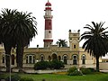
State House with lighthouse in the background
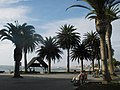
Beach promenade at the pier

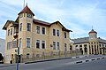
Former train station, today Swakopmund Hotel

The old district court

Old Antonius building, a former Franciscan hospital
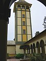
Dam tower of the Woermannhaus

The landing stage before the renovation in 2006
The knight's castle , behind it the former Hotel Fürst Bismarck


.jpg)
annotation
- ↑ Note: This article contains characters from the alphabet of the Khoisan languages spoken in southern Africa . The display contains characters of the click letters ǀ , ǁ , ǂ and ǃ . For more information on the pronunciation of long or nasal vowels or certain clicks , see e.g. B. under Khoekhoegowab .
Individual evidence
- ^ High-rise proposal overshadows Swakop's traditional skyline. The Namibian, October 5, 2016.
Central | Kramersdorf | Matutura / DRC | Mile 4 | Mondesa | River Plots ( Rössmund ) | Tamariskia | Vineta (Waterfront) | Bird Beach (Hage Heights, Ocean View)