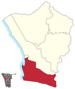
Walvis Bay Land
 Details |
Constituency Walvis Bay Country Walvis Bay Rural |
| Basic data | |
|---|---|
|
State region |
Namibia Erongo |
|
Population area District administrative seat |
26,489,9134 km² of Walvis Bay |
| Election information | |
|
Registered voters |
19390 |
Walvis Bay-Land ( English Walvis Bay Rural ) is a constituency in the Namibian region of Erongo . It was created in 2013 by separating the former Walvis Bay constituency. 26,489 people live in an area of 9134 square kilometers (2011).
The area includes, among other things, Langstrand and Dolfynstrand and encloses the constituency of Walvis Bay City ( English Walvis Bay Urban ).
elections
| choice | Surname | Political party |
|---|---|---|
| 2013 (by-election) 1 | Johannes Nangolo | SWAPO |
| 2015 | Johannes Nangolo | SWAPO |
| 2020 |
1 constituency was only founded in 2013.
See also
Individual evidence
- ^ In Government Gazette 5261 GG 1 (Aug. 9, 2013) Retrieved April 13, 2017
- ↑ Namibia 2011 Population and Housing Census Preliminary Results. (PDF) National Planning Commission, 2012, pp. 41/42. (English).
- ↑ Regional Conuncils Election Results. Electoral Commission of Namibia, 2015. ( Memento of the original dated December 8, 2015 in the Internet Archive ) Info: The archive link was inserted automatically and has not yet been checked. Please check the original and archive link according to the instructions and then remove this notice.
Coordinates: 23 ° 3 ′ S , 14 ° 56 ′ E

