Waterberg
| Waterberg | ||
|---|---|---|
|
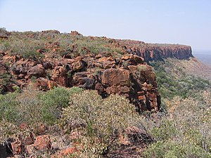
Edge of the Waterberg Plateau |
||
| height | 1885 m | |
| location | Otjozondjupa , Namibia | |
| Coordinates | 20 ° 27 '2 " S , 17 ° 14' 17" O | |
|
|
||
| Type | Table Mountain | |
| Age of the rock | 150 million years | |
| First ascent | unknown | |
The Waterberg , historical name Omuverumue , is a prominent table mountain in Namibia , east of Otjiwarongo . It is about 48 kilometers long and 15 kilometers wide and towers over its surroundings by almost 200 m . Since 1972, a national park has been set up on the 40,500 hectare plateau of the Waterberg and around it with the Waterberg Plateau Park .
history
The place became particularly famous through the battle of Waterberg on August 11th and 12th, 1904 during the Herero uprising .
Today a memorial plaque for the fallen Herero and a German military cemetery commemorate the event.
geology
The Waterberg was originally along with the 70 km southwest located Etjo ( 2082 m ) and a few kilometers south of Waterberg lying small Waterberg ( 1930 m ) part of a much larger plateau, which before 120-190 million years ago in the Karoo-time deposited has been. 150 million years ago, the terrain was raised and the weathering dissolved the surrounding softer rock.
Soft and firm sands on a waterproof layer, which is slightly higher than the surrounding area, form the basis for the diverse habitats on the Waterberg. The sandstone absorbs the rain like a sponge. The water seeps down and emerges at springs at the edge of the boundary layer, which slopes slightly to the southeast.
literature
- Daryl and Sharna Balfour: Etoscha - Naturparadies in Afrika , Franckh-Kosmos, Stuttgart, 1992 ISBN 3-440-06499-9
- Jürgen Leskien : Dark shadow on the Waterberg. African Night Talks , Schwartzkopff Buchwerke, Berlin 2004, ISBN 978-3-93773-810-9 .
Web links
- Official park brochure (PDF; 2.63 MB)
Individual evidence
- ^ Nikolai Mossolow: Waterberg. Contribution to the history of the Otjozondjupa mission station, the Kambazembi tribe and the Hereroland , ISBN 0-620-05473-5 / ISBN 0-620-05473-5 , page 3
- ↑ Waterberg on a map from the time of German South West Africa


