
Sossusvlei


The Sossusvlei ( ) is located in Namibia and is a beige salt-clay pan (" vlei ") in the Namib , surrounded by sand dunes , which only carries water in rare good years of rain. Then a few centimeters to several meters deep lake forms in the Vlei at the end of the Tsauchab for a short time. Sossus means "blind river" in the Nama language . “Blind” refers to the fact that the Tsauchab river , which flows in the direction of the Atlantic from a mountainous region inland after heavy rainfall, ends or silts up in the sand dunes of the Namib coastal desert at Sossusvlei - around 50 km from the sea. The area is part of the Namib-Naukluft National Park .
The Sossusvlei has been part of the UNESCO World Heritage of the Namib Sand Sea since June 21, 2013 . In general, the entire area, including the surrounding dune landscapes and vleis, is referred to as Sossusvlei . It is one of the three areas of the Namib-Naukluft Park (next to Naukluft and Namib ).
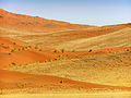
The surrounding orange-colored dunes are among the highest in the world with a height difference of more than 380 meters compared to the pan. The tallest among them is Big Daddy , also called Crazy Dune . The orange color of the sand is caused by iron oxide, black areas of the dunes are made of magnetite .
Emergence
The vlei was created by silting up the Tsauchab , which originally probably flowed into the Atlantic. The Deadvlei and Hiddenvlei lying next to it, each cut off from the water by a dune, reflect this development to this day. There are dead trees that decay very slowly due to the dry climate. Near the park entrance is the Sesriem Canyon , which has been dug into the gravel for over a kilometer.
Flora and fauna
Despite the extreme living conditions, there are many creatures adapted to the desert in Sossusvlei. In addition to mammals such as the gauntlet and the desert gold mole , there are u. a. also the anchieta sand lizard , the mist drinker beetle and the puff adder . Camel thorn trees grow particularly frequently along the waterways, and the Nara , which is endemic to the Namib, can be found on the dunes .
tourism
.jpg)

In addition to the dunes, the special tourist attractions include the Hiddenvlei at the end of the street and the Deadvlei at the end of Sossusvlei.
From the park entrance of the Namib-Naukluft National Park near Sesriem , an approximately 65-kilometer-long, dune-lined asphalt road leads towards Sossusvlei, which branches off the main road C27 . The road was renewed in 2006 and is in very good condition. The last five kilometers can only be covered on foot or in four-wheel drive vehicles.
In the summer months it is extremely hot there, but the winter months are also characterized by warm temperatures.
The state accommodation of Namibia Wildlife Resorts offers the possibility to drive to Sossusvlei before sunrise and after sunset; all other visitors are only allowed to enter between sunrise and sunset.
Some tour operators also offer flights over the dune landscape, either with small planes or hot air balloons. The planes usually take off in Swakopmund or Walvis Bay , the hot air balloons in the early morning in Sesriem.
gallery
Dunes at Sossusvlei

Sossusvlei from space


See also
Web links
- Official brochures on Sossusvlei ( Memento of August 7, 2014 in the Internet Archive )
- Entry on the UNESCO World Heritage Center website ( English and French ).
Individual evidence
- ↑ Sossusvlei. Namibia Tourism Board. ( Memento of July 4, 2010 in the Internet Archive ) Retrieved June 15, 2017.
- ↑ Allgemeine Zeitung , Windhoek, Running through the Namib Desert (August 2, 2005)
- ↑ The dunes around the Sossusvlei
Coordinates: 24 ° 44 ′ S , 15 ° 17 ′ E