Namib Sand Sea
| Namib Sand Sea | |
|---|---|
|
UNESCO world heritage |
|

|
|
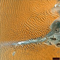
| The blind end of the Tsauchab River, surrounded by dunes, on the eastern edge of the central part of the "Namib Sand Sea" (satellite photo) |
|
| National territory: |
|
| Type: | nature |
| Criteria : | (vii), (viii), (ix), (x) |
| Surface: | 3,077,700 ha |
| Buffer zone: | 899,500 ha |
| Reference No .: | 1430 |
| UNESCO region : | Africa |
| History of enrollment | |
| Enrollment: | 2013 (session 37) |
The Namib Sand Sea ( English Namib Sand Sea ) has been a UNESCO World Heritage Site since June 20, 2013 . It occupies the central part of the Namib in Namibia and is the country's second World Heritage Site . It was declared a World Heritage Site because of its outstanding desert landscape, rich flora and fauna with great endemic diversity and geological processes.
The sand sea covers large parts of the Namib-Naukluft Park south of the Kuiseb via Sesriem with the Sesriem Canyon and the Sossus and Deadvlei to the farms of Canaan and Kamaland in the south and further west to Gibraltar on the Atlantic coast and from there northwards the coastline to Sandwich Harbor . The world heritage area extends over a total of 30,777 square kilometers .
Web links
- Entry on the UNESCO World Heritage Center website ( English and French ).
- Namib Sand Sea. (pdf, 22 MB) World Heritage Nomination. World Heritage Center, accessed February 12, 2019 .
Individual evidence
- ^ Namibia gets second World Heritage Site. The Namibian, June 20, 2013 Retrieved June 20, 2013
Coordinates: 24 ° 45 ′ S , 15 ° 16 ′ E
