Outapi
| city Outapi Uutapi (historical)
|
|||
|---|---|---|---|
|
|||
| Main street in Outapi | |||
| motto | Quality Services, Development and Prosperity (quality service, development and prosperity) | ||
| Basic data | |||
|
Population Area Population Density |
6600 (2011 census) 10.8 km² 611.7 inh / km² |
||
|
State Region Constituency |
Namibia Omusati Outapi |
||
| Establishment date | |||
|
License plate phone code |
UP 60 |
||
| Website | outapitc.org.na | ||
|
Political data
Mayor : Mateus Ndeshitila ( SWAPO ) Chief Executive Officer : Oswin O. Namakalu Last election: 2015 Next election: 2020 City administration address: |
|||
|
Geographical data
Geographic coordinates : -17.50368, 14.98786 |
|||
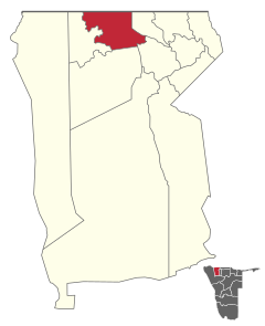
Outapi (often still using the old spelling Uutapi ) has been the capital and administrative seat of the Omusati region in Namibia since 1998 and has 6,600 inhabitants (as of: 2011 census). It lies in the constituency of the same name .
The current (as of August 2016) mayor is Selma Nelago Asino ( SWAPO ).
Outapi has had city status since 1997 and is considered the fastest growing city in Omusati.
climate
Outapi has a semi-arid climate (steppe climate BSh, according to the climate classification according to Köppen and Geiger ), with hot summers and relatively mild winters (warm days and cold nights). The average annual rainfall is about 470 mm; the main precipitation occurs in summer.
Local politics
In the 2015 local elections , there were no other parties other than SWAPO , so it won all seven seats in the local administration.
Economy and Infrastructure
Outapi has an airfield, a hospital, several schools, and various retail stores. There are branches of the three major banks in Namibia as well as several hotels. There are more than 300 market stalls on the two large markets “Outapi Open Market” and “Onhimbu Open Market”.
The Olufuko Festival has been taking place in Outapi since 2012 . It is a combination of a business fair with cultural events at which the initiation of young women is celebrated. In addition to various craft and market stalls, there are also a lot of food stands. Former President Sam Nujoma is the patron of the Olufuko Festival.
Attractions
- The Outapi War Museum is located underground in the former Ohatopi base of the South African Army
- The Ombalantu baobab , a national monument , locally also known as the tree of life or Omukwa waa Mbalantu, whose mighty trunk was used as a post office , chapel and café in the past , has a diameter of 26.5 meters and a height of 28 meters. The baobab tree (Adansonia digitata) is said to be 800 years old.
Town twinning
Web links
Individual evidence
- ↑ a b c d Namibia 2011 Population and Housing Census Preliminary Results. Namibia Statistics Agency, April 2012 , accessed May 9, 2012.
- ↑ Town Current Developments 2009, Outapi Town Council ( Memento from July 22, 2011 in the Internet Archive )
- ↑ Official election results of the regional and local elections 2015, ECN, December 4, 2015 ( Memento of December 10, 2015 in the Internet Archive ) (PDF; 150 kB)
- ^ Outapi making its mark, Namibian Sun, September 1, 2010
- ^ Outapi War Museum. Museums Association of Namibia. Retrieved August 24, 2016.
- ↑ Tanja Bause: Namibia: History of the Ombalantu Baobab Tree . In: The Namibian , August 31, 2010.
Coordinates: 17 ° 30 ′ S , 14 ° 59 ′ E


