Ugab
| Ugab | ||
|
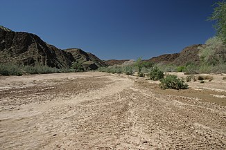
Dry river bed of the Ugab not far from the "Brandberg West" opencast mine |
||
| Data | ||
| location | Namibia | |
| River system | Ugab | |
| muzzle | in the Atlantic Coordinates: 21 ° 11 ′ 21 ″ S , 13 ° 37 ′ 44 ″ E 21 ° 11 ′ 21 ″ S , 13 ° 37 ′ 44 ″ E
|
|
| length | 450 km | |
| Catchment area | 29,355.496 km² | |
The Ugab ( Nama ǃUǂgab ) is an ephemeral (temporarily water-bearing) river that rises between the places Otjiwarongo and Outjo . With its source rivers it is 450 kilometers long and flows into the South Atlantic at Ugabmund .
Hydrology

The Ugab belongs to the northern Namib water region . Its catchment area covers 29,355.496 km² and extends from the confluence with the Atlantic 200 kilometers north of Swakopmund inland via Outjo and Otjiwarongo to Otavi . Annual rainfall is sporadic and irregular and occurs mostly during the rainy season in summer. The amount of precipitation increases continuously from the coast with less than 50 mm / a inland and reaches up to 530 mm / a in the upper reaches of the Ugab. About 300 millimeters fall annually in about half of the catchment area. Heavy rainfall in the eastern upper catchment area leads to the “Agreement” of the Ugab, which can then carry considerable water over several days. Characteristic is the decrease in the amount of water in the lower reaches due to infiltration into the sandy subsoil, so that the Ugab rarely reaches the coast. After the flood, the river quickly dries up except for individual pools and damp depressions, although in some cases considerable underground water flows can still be detected, so that there is a small, year-round wetland in the estuary .
vegetation
The catchment area's vegetation ranges from desert (3%), through semi-desert vegetation and savanna transition zone (17%), Mopane savannah (37%) and thorn bush savannah (9%) to mountain savannah or karst valley with 34% in the upper catchment area. Striking and characteristic of all ephemeral rivers in the Namib is the more or less dense band of gallery forest in the Ugab, which forms a strong contrast to the arid landscape of the Namib, especially in the lower reaches . The gallery vegetation mainly contains camel thorn ( Acacia erioloba ), ana tree ( Faidherbia albida ), tamarisk ( Tamarix spec. ), But also leadwood ( Combretum imberbe ), mopane ( Colophospermum mopane ) and salavadora , some with a dense population of large trees. Different grasses, cyperus and reeds appear as herbaceous species . About three months after a flood, two to three meter high grasses and perennials can be found in the otherwise dry valley areas. As linear oases, the gallery forests represent the livelihood for wildlife and the people who live there.
Use and settlement
The Ugab and its catchment area allow its only 35,000 inhabitants a wide range of land use . In the upper reaches, due to the sufficient rainfall, there is predominantly agriculture and grazing with around 300 commercial farms, which together make up around 60 percent of the catchment area. 38 percent of the catchment area is in tribal hands as communal land. In the dry lower reaches there are only a few smaller, often temporary, settlements of wandering shepherds , who drive their animals to the most productive pastures in Damaraland , depending on the rainfall . In the entire catchment area, mining also takes place on a predominantly smaller scale. In addition, the Ugab offers enormous touristic potential that has so far largely been untapped. In addition to the spectacular geological formations, especially in the lower reaches of the desert elephants , the black rhinoceros reintroduced by the ' Save the Rhino Trust ' and a smaller number of free-roaming lions can be found between the Ugab and the other dry rivers of the northern Damaraland, depending on the rainfall and food supply commute.
literature
- CW Passchier, RAJ Trouw, A. Ribeiro et al .: Tectonic evolution of the southern Kaoko belt, Namibia. , In: Journal of African Earth Sciences, No. 35, 2002, pp. 61-75. ( available online )
- Mary Seely, Kathryn M. Jacobson, Peter J. Jacobson: Ephemeral Rivers and Their Catchments - Sustaining People and Development in Western Namibia . Desert Research Foundation of Namibia, 1995, ISBN 978-99916-709-4-2 .
- Klaus Hüser, Helga Besler, Wolf Dieter Blümel, Klaus Heine, Hartmut Leser, Uwe Rust : Namibia - A Landscape Studies in Pictures . Klaus Hess, Göttingen / Windhoek 2001, ISBN 978-3-933117-14-4 .
- IW Hälbich and EE Freyer: STRUCTURE AND METAMORPHISM OF DAMARAN ROCKS IN THE UGAB PROFILE , In: Communs Geol. Surv. SW Afr./Namibia, 1/1985, No. 97. ( available online )
Web links
Individual evidence
- ↑ Mapping the Major Cathments of Namibia. Ben Ben J. Strohbach, National Botanical Research Institute, pp. 5-6.

