Kunene (river)
|
Kunene Cunene |
||
|
Map of the Kunene with its tributaries, the Oshana system and the Etosha pan |
||
| Data | ||
| location |
|
|
| River system | Kunene | |
| source | Bié highlands , Lundaschwelle | |
| Source height | 1800 m | |
| muzzle |
South Atlantic , Foz do Cunene (Kunenemund) coordinates: 17 ° 14 '58 " S , 11 ° 45' 12" O 17 ° 14 '58 " S , 11 ° 45' 12" O |
|
| Mouth height | 0 m | |
| Height difference | 1800 m | |
| Bottom slope | 1.7 ‰ | |
| length | 1050 km | |
| Catchment area | 110,200 km² | |
| Discharge at the Ruacana gauge (64740001) A Eo : 89,600 km² Location: 200 km above the mouth |
MNQ 1961-1997 MQ 1961-1997 Mq 1961-1997 MHQ 1961-1997 |
38 m³ / s 164 m³ / s 1.8 l / (s km²) 480 m³ / s |
| Left tributaries | Osse (Chitanda), Otjindjangi | |
| Right tributaries | Catape, Que, Kalonga, Caculavar | |
| Reservoirs flowed through | Gove Dam , Calueque Dam | |
| Residents in the catchment area | 1,988,000 | |
|
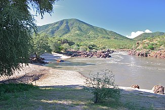
Kunene near Epupa |
||
The Kunene is a river in Angola and Namibia in southwest Africa .
course
The 1050 kilometer long river, which carries water all year round, has its source at around 1800 meters in the Angolan highlands of Bié , the humid Lunda wave . While it has a multitude of rapids and gorges in the approximately 300 km long upper course , in the middle course it flows practically evenly through part of the Kalahari basin before it meets the Great Rim just before the Namibian border . From there to the mouth of the Atlantic there are numerous rapids and waterfalls , the most famous and at the same time most spectacular are the Ruacana waterfalls near the eponymous town of Ruacana and the grandiose Epupa falls .
From Ruacana, where the Kunene meets the Namibian border, the river forms the natural border between Angola and Namibia in a westerly direction, before flowing into the South Atlantic in a delta up to 30 kilometers wide .
Hydrometry
The flow of the Kunene shows a pronounced seasonality. After the heavy rainfall in the headwaters in summer , the runoff in wet years is up to 1300 million m³, in dry years it hardly reaches 50 million m³. The flood peak migrates downstream during the rainy season and reaches the lower reaches at Ruacana in May .
The discharge would be measured from 1961 to 1997 at the Ruacana station about 200 km above the mouth in m³ / s (read from the diagram).

On February 16, 2020, the Kunene above the Ruacana Falls reached its highest level since at least 1982, with a water volume of 2500 cubic meters per second.
Water use
The general abundance of water and the permanent flow of water in the river have repeatedly led to plans for dam projects ( Cunene project ). While the Kunene at Ruacana is already dammed, which has taken much of the splendor of the Ruacana waterfalls, the planned dam at the Epupa Falls has met with fierce resistance from both nature conservationists and the local Himba , as the construction of the dam is traditional Would destroy tribal territory.
A pipeline runs from a pumping station at the Calueque Dam , before the Ruacana Waterfalls, and a canal to Namibia to improve the water supply in the northern region. The water is used to irrigate agricultural areas and is required in four water treatment plants to produce drinking water. This water use started with the Cunene project.
River history
Up until the Tertiary , the Kunene flowed into today's Etosha Pan , which at that time formed an inland delta and Lake Ekuma, similar to the Okavango delta . Only after the splitting up of the supercontinent Gondwana and the drifting apart of Africa and South America did the Kunene shift to the Atlantic.
See also
Web links
Individual evidence
- ↑ a b c Source Book - Africa's River Basin Organization
- ^ Hydrology of the Kunene Basin
- ↑ a b [1] The macroinvertebrates of the Cunene River from the Ruacana Falls to the river mouth and assessment of the conservation status of the river
- ^ Flood reaches Foz de Cunene. Informanté , February 16, 2020.
- ↑ Matheus. Kuutondokwa Shuuya: Assessment of the impacts of pollution on water quality in the Calueque-Oshakati Canal in north-central Namibia ( page no longer available , search in web archives ) Info: The link was automatically marked as defective. Please check the link according to the instructions and then remove this notice. . Master Thesis, University of Zimbabwe , Faculty of Engineering, June 2008, p. 2 and 28 (PDF document p. 13 and 39), online at www.ir.uz.ac.zw (English)


