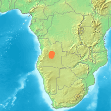
Bié highlands
The Bié (or Bihé ) highlands are located in the heart of Angola ( Africa ). It rises up to 2619 m high.
geography
In the north the highlands merge into the Lower Guinea Sill and in the northeast into the Congo Basin . More in the east than in the northeast it merges almost seamlessly with the Lundaschwelle ; in the east, however, it also slopes down to the rather extensive valley of the Zambezi . In the southeast it goes over into the Okavango Basin and in the south the Ovamboland joins. In the southwest the Bié highlands merge into the 2275 m high Shelagebirge ( Serra da Chela ). In the west it slopes down to the narrow lowlands on the Atlantic coast .
The Bié highlands, which together with the Lunda highlands make up most of Angola, is mountainous in the middle of the country; towards the south it gradually drops and is flat there. The highest point in the Bié highlands is the Môco at 2619 m.
The Benguela Railway crosses the highlands from west to east. The largest town in the highlands is Huambo .
Biggest rivers
From about the center of the Bié highlands, numerous small and large rivers run radially in many directions:
- Kwanza (Kuanza) - towards the northwest
- In the east, the Zambezi , which comes from the north, flows past in a southerly direction
- Cuando (Kuando) - towards the southeast
- Cubango - Okavango - towards the south / southeast
- Kunene (Cunene) - towards the southwest
- Kassai - to the east
- In the west (Atlantic) only small rivers flow
Biggest place
- Huambo (New Lisbon)
