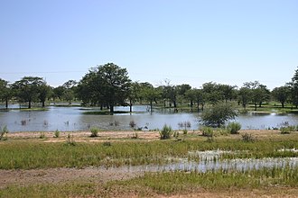
Oshana system

The Oshana system , also known as the Cuvelai system or Cuvelai wetland, is an extensive network of poorly sloping, shallow drainage channels and depressions running in north-south direction, the so-called Oshanas , in north-central Namibia . It stretches over large parts of the eponymous Oshana region - from Cuvelai in the highlands of Bié in the north to the north bank of the Etosha pan and from Ruacana in the west to Ondangwa in the east and is the dominant landscape in north-central Namibia. The Cuvelai System is a special wetland based on the Ramsar Convention .
Geographical description and natural water balance
The Oshanas originate around 100 km north of the Namibian border on Angolan territory, from where they flow south, unite to form the Ekuma and finally flow into the Etosha pan.
As Oshanas , actually in Oshivambo Iishana are referred to by the term in the regional language Oshivambo lying parallel wide dry valleys whose boundary is given by slight elevations sandy-loamy deposits. The irregular water flow, which periodically leads to elongated lakes and swamp areas, depends on the rainfall in southern Angola. While the western Oshanas are filled by precipitation in the Angolan highlands, the water of the eastern Oshanas mostly comes only from local rainfall.
When dry, the Oshanas form open, grassy, but otherwise vegetation-free depressions ("pans"). Only the edges and higher areas are overgrown with Mopane and Makalani palms ( Hyphaene petersiana ). The water flow is limited to the rainy season in summer. After massive rainfall in the greater region of northern Namibia / southern Angola, the channels and depressions in the area fill up; then larger floods, the so-called Efundjas , occur. Because of the wide ramifications and the slight slope of the Oshanas, large areas of north-central Namibia are then under water. With an extension of over 30,000 km², the Oshana system then temporarily forms the most important wetland in Namibia . During the Efundja, there are 260 species of birds in the Oshana area, including 90 species specific to wetlands such as flamingos , pelicans and saddle storks . The canals are then full of fish that are caught by the locals with their bare hands or simple fish traps. Even after the rains, the oshanas remain filled as shallow lakes for a long time, which slowly evaporate because impermeable layers of soil prevent the water from seeping away quickly.
A research team with the participation of the Federal Institute for Geosciences and Natural Resources assumes an underground water reservoir in Ohangwena of 20 billion cubic meters in size, which could supply the region with drinking water for up to 400 years.
Settlement area
The contiguous area of the Oshana system and the Etosha pan forms the livelihood for 45 percent of Namibia's population.
The Oshanas and their summer flood are essential for Ovamboland. The predominant sandy soils in the region and the Kalahari sandstone are extremely poor in nutrients and hardly offer any water retention capacity. Only the flood water ensures a replenishment of the groundwater reserves and a dense growth of grass that is used for pasture farming. In addition, there are many fish in the flooded pools and gullies during the summer months, which are caught by the residents and used fresh or dried as food. However, the ponds and swamps also offer ideal breeding grounds for mosquitoes, so that among other things malaria is widespread.
Since a larger Efundja had last occurred in the 1950s and since then there had been a massive increase in population, many settlements and pasture areas were expanded to include seldom flooded hollows and oshanas in the following decades . In the dry season, the country's carrying capacity is increasingly exceeded; the groundwater reserves are exhausted more quickly. With higher floods or even a large Efundja , as it happened again between 2008 and 2011, this leads to great damage and loss of house and livestock.
The sufficient availability of water and the entry of nutrient-rich sediments allow for productive agriculture, which is operated exclusively as a subsistence economy . Industrial agriculture hardly takes place despite the suitability of the land. The main crops are melons, pumpkins, corn, millet and beans. In addition, there is livestock farming.
Due to the good conditions, the Oshana region has a high population density and is therefore highly sprawled. The vast dry forests mentioned in reports from the 20th century have now disappeared and were felled to meet the high demand for firewood.
See also
literature
- John Mendelsohn, Beat Weber: Cuvelai - The Cuvelai Basin its water and people in Angola and Namibia. Development Workshop, 2011. ( available online )
- Ministry of Agriculture, Water and Forestry (Ed.): Cuvelei-Etosha Groundwater Investigation. November 2006.
- CJ Hay, FH van der Bank, JT Ferreira: The effect of the artificial linkage between the Kunene River and the Cuvelei System on the fish Fauna in Owambo, Namibia. In: Madoqua, 19 (2), 1997, pp. 99-105. ( available online )
Web links
- Integrated Water Resources Management in Northern Namibia (English)
- Map Hydrography of Namibia II: perennial rivers and the Cuvelai system. (English)
Individual evidence
- ↑ Ernst Klimm, Karl-Günther Schneider, Sigrid von Hatten: Das Südliche Afrika. Volume 2: Namibia - Botswana (= Scientific Country Customers. Volume 39). Wissenschaftliche Buchgesellschaft, Darmstadt 1994, ISBN 3-534-07188-3 , p. 123.
- ↑ Water for Namibia Researchers find gigantic sea under the desert. In: Spiegel Online , July 21, 2012; Aquifer in the north re-evaluated. Allgemeine Zeitung , July 10, 2017.
- ↑ Etosha Pan. In: Ramsar Sites Information Service .
- ↑ Climate-resilient development & enhanced adaptive capacity for disaster risk in Angola's Cuvelai River Basin. Introduction. In: Climate Change Adaptation , UNDP (English).

