
Niseko Shakotan Otaru Kaigan Quasi-National Park
|
Niseko Shakotan Otaru Kaigan Quasi-National Park
|
||
 Mekunnai mountain |
||
| location | Hokkaidō , Japan | |
| surface | 190.09 km² | |
| WDPA ID | 3097 | |
| Geographical location | 42 ° 53 ' N , 140 ° 33' E | |
|
||
| Setup date | 1963 | |
| administration | Hokkaido Prefecture | |

The Niseko-Shakotan-Otaru-Kaigan-Quasi-National Park ( Japanese ニ セ コ 積 丹 小樽 海岸 国 定 公園 , Niseko-Shakotan-Otaru Kaigan Kokutei Kōen ) is a quasi-national park in Japan . The park, founded in 1963, extends over an area of approx. 190 km², which is divided into two areas:
- Coastline around Cape Kamui and Cape Shakotan
- Niseko Mountains
With the IUCN Category II, the park area is classified as a national park . The Hokkaidō Prefecture is responsible for the management of the park.
gallery

Cape Kamui
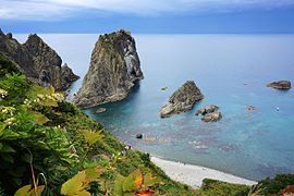
Shimamui coast, Cape Shakotan

Mountain Chise
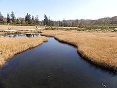
Marshland in the quasi-national park


.jpg)
See also
Web links
Commons : Niseko-Shakotan-Otaru-Kaigan-Quasi-National Park - Collection of pictures, videos and audio files