
Nordschleusenbrücke
Coordinates: 53 ° 34 ′ 18 ″ N , 8 ° 33 ′ 12 ″ E
| Nordschleusenbrücke | ||
|---|---|---|
 |
||
| use | Railroad, road transport | |
| Convicted | Brückenstraße, Columbusinsel siding of the Bremen port railway |
|
| Subjugated | Connecting channel Wendebecken – Kaiserhäfen |
|
| place | Harbors district , Bremen | |
| construction | Steel truss - swing bridge | |
| overall length | 111.9 m | |
| width | 19 m | |
| Longest span | 78.5 m | |
| start of building | 1929 | |
| opening | 1931 | |
| Status | in operation | |
| location | ||
|
||

The Nordschleusenbrücke is a swing bridge opened in 1931 in the Bremerhaven overseas port area , which is used by rail and road traffic. It is considered the largest swing bridge in Germany.
The structure is located at the northern end of Columbus Island, immediately east of the north lock . It connects the island to the mainland via the canal between the Wendebecken and the Imperial Ports.
The bridge has two cantilever arms of different lengths: the shorter one is 33.4 m long, the longer one 78.5 m long. The bridge girder weighs 2760 t. It crosses two railway tracks, two lanes for road traffic and a pedestrian path.

Location of the Nordschleusenbrücke in the Bremerhaven overseas port area
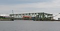
Nordschleusenbrücke from the south, behind it the turning basin
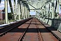
Railway tracks on the Nordschleusenbrücke


Web links
Individual evidence
- ↑ a b Nordschleusenbrücke. In: brueckenweb.de. Frank Selke, accessed November 13, 2017 .
- ^ Karl Gotsch: Nordschleusenbrücke. In: bridge database. Retrieved November 13, 2017 .