Nosy Ve
| Nosy Ve | ||
|---|---|---|
| Waters | Indian Ocean | |
| Geographical location | 23 ° 38 ′ 0 ″ S , 43 ° 36 ′ 0 ″ E | |
|
|
||
| length | 1.2 km | |
| width | 400 m | |
| Residents | uninhabited | |
Nosy Ve (also written Nossi-Vey or Nossy-Vey during the French colonial era ) is a small, now uninhabited island on the southwest coast of Madagascar near the mouth of the Onilahy . The extension in the northwest-southeast direction is 1200 meters and 400 meters in the northeast-southwest direction. The island is surrounded by a fringing reef about 4.5 kilometers long .
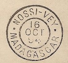
In 1876 a small settlement was created by French colonists, which was attacked several times by the local Mahafaly in the following years and was therefore abandoned. After the first Franco-Hova war, the island was repopulated by the French in 1888. A French post office existed on the island in the early 1890s. After Madagascar had been conquered in 1895 by a French expedition corps under General Joseph Gallieni , the island's importance as a safe place to settle decreased and the inhabitants settled in Toliara , which is further north on the main island. Today you can still find the remains of some graves from the time of the French settlement.
The island is the southernmost, continuously occupied breeding ground for the red-tailed tropical bird .
Web links
- Nosy Ve at www.madacamp.com , accessed January 15, 2014
Individual evidence
- ^ Revue francaise de l'etranger et des colonies et Exploration, Volume XXXI, 1896 , p. 26
- ↑ Olivier Langrand (1981): Nidification du Paille-en-queue à queue rouge ( Phaeton rubricauda ) sur le territoire malgache. Revue Française d'Ornithologie , Volume 51, pp. 338–339.

