Pavlopetri
As Pavlopetri ( Greek Παυλοπέτρι ) an archaeological site is off the coast of southern Laconia in Greece called. It is a Bronze Age city that is now below the level of the Mediterranean due to subsidence and sea level rise .
location
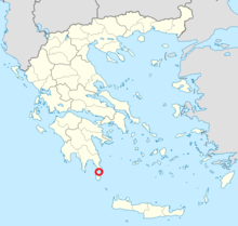
The archaeological site is located on the small island of Pavlopetri between the southeastern tip of the Peloponnese and the island of Elafonissos at a depth of three to four meters on a sandy seabed.
History of exploration
The site was discovered in 1967 by Nicholas Flemming, then at the National Oceanography Center in Southampton, and mapped in 1968 by a team of Cambridge archaeologists . The archaeological field studies revealed an almost complete floor plan with streets, buildings and graves.
The underwater archaeological research was only resumed after 40 years in 2009 as a joint project by British and Greek researchers. The archaeological team, which includes Nic Flemming, is led by Jon Henderson from Nottingham University together with Elias Spondylis from the Ephorate for Underwater Antiquities of the Greek Ministry of Culture.
The 2009 field studies mainly focused on surveying and mapping the site. Pavlopetri is the first sunken city to be digitally measured in three dimensions. Sonar measurement techniques developed by the military and in oil prospecting were used.
From October 2009, four more campaigns for field studies are planned on site. These are not excavations. The research results are to be published in full in 2014.
Dating
Initially the ruins were from the Mycenaean period 1600 to 1100 BC. Chr. Been attributed. Later research showed an older settlement period. Most of the buildings date from the early Bronze Age from around 2800 BC. BC, individual stone box graves are much younger and come from the Mycenaean culture of the late Bronze Age around 1680 to 1180 BC. Chr.
Ceramic shards from the end of the Neolithic around 3000 BC are evidence of an even older settlement. BC, which were found in recent explorations. The media therefore refer to Pavlopetri as the oldest sunken city in the world.
It is believed that the city was built around 1000 BC. Sank through seismic activity in the sea. Since it was then inaccessible, it was neither built over nor impaired by agriculture.
The town
The city's buildings have been partially preserved. Over the centuries, the site has been affected by erosion , but the foundation walls and floor plan can be almost completely reconstructed. There are at least 15 buildings. The latest discoveries in 2009 cover 9,000 square meters alone. It is believed that the city was once 100,000 square feet; The team of archaeologists has mapped around half of the area. Residential houses, streets, courtyards and buildings for probably religious purposes, crypts and graves. The site is currently being damaged by anchors from boats, tourists and souvenir hunters.
Individual evidence
- ^ National Oceanography Center. Retrieved May 9, 2010 .
- ↑ a b c The Epoch Times, November 16, 2009: Pavlopetri - ancient sunken city , accessed May 9, 2010
- ↑ BBC News "Sea gives up secrets to experts". Retrieved May 9, 2010 .
- ^ Science News: World's oldest submerged town dates back 5,000 years. Retrieved May 9, 2010 .
- ^ University of Nottingham: World's oldest submerged town dates back 5,000 years , press release October 16, 2009
- ↑ University of Nottingham: Race to preserve the world's oldest submerged town ( page no longer available , search in web archives ) Info: The link was automatically marked as defective. Please check the link according to the instructions and then remove this notice. , Press release of May 12, 2009
- ^ University of Nottingham: World's oldest submerged town dates back 5,000 years. Retrieved May 9, 2010 .
- ^ University of Nottingham: Race to preserve the world's oldest submerged town . (No longer available online.) Formerly in the original ; Retrieved May 9, 2010 . ( Page no longer available , search in web archives ) Info: The link was automatically marked as defective. Please check the link according to the instructions and then remove this notice.
Web links
- Doris Marszk: Ancient: The oldest sunken city already inhabited in the Neolithic. www.wissenschaft-aktuell.de, October 19, 2009, accessed on April 20, 2012 .
- EPOC of October 22, 2009: Underwater city is almost 6000 years old
- The Epoch Times of November 16, 2009: Pavlopetri - ancient sunken city
- Sideeffects: Pavlopetri is over 5000 years old
- Excavation report from 1968 (English; PDF; 8.1 MB)
- Film / video science documentary, BBC / ZDF 2011, dive into the past - archeology in 3D, directed by Paul Olding, 50 minutes
Coordinates: 36 ° 31 ′ 1.1 ″ N , 22 ° 59 ′ 19.1 ″ E

