Peña Maín
| Peña Maín | |
|---|---|
|
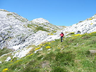
On the south side of the Peña Maín, at the back in the center of the picture the highest peak, the Cabeza la Mesa |
|
| Highest peak | Cabeza la Mesa ( 1605 msnm ) |
| part of | Picos de Europa , Cantabrian Mountains |
| Coordinates | 43 ° 15 ′ N , 4 ° 47 ′ W |
The Peña Maín is a mountain range in the northern part of the Massif Central of the Picos de Europa , which are part of the Cantabrian Mountains in northern Spain . The Peña Maín extends for a little more than five kilometers within the Picos de Europa National Park, mainly in a west-east direction and is framed in the north and east by the Río Duje , a tributary of the Río Cares . Tielve is located north of the mountain range , Sotres to the southeast and Bulnes to the southwest . The highest peak is the Cabeza la Mesa (1605 m). While the forest in the southern part of the Peña Maín reaches heights of over 1000 meters, the south side is hardly forested. The west side of the mountain range is crossed by the Funicular de Bulnes , an underground funicular railway.
Individual evidence
- ↑ a b Adrados Ediciones: Macizos Central y Oriental de los Picos de Europa. Mapa Topográfico Excusionista. San Claudio (Asturias) 2003, ISBN 84-933177-8-0
- ↑ Cordula Rabe: Picos de Europa. 3rd edition, Munich 2015, ISBN 978-3-7633-4361-4 , pp. 102-105 ( Google books )
