
Petit Be
| Petit Be | ||
|---|---|---|
.JPG) |
||
| Waters | English Channel | |
| Geographical location | 48 ° 39 ′ 9 ″ N , 2 ° 2 ′ 18 ″ W | |
|
||
| length | 200 m | |
| width | 100 m | |
| surface | 2 ha | |
| Residents | uninhabited | |

Petit Bé (also Petit Bey) is a tidal island ( French Île-de-marée ) in the English Channel off Saint-Malo , which is accessible from the mainland via its neighboring island Grand Bé at low tide .
Between 1689 and 1697, the Fort du Petit Bé was built on Petit Bé . It is part of the ring around Saint-Malo designed by Sébastien Le Prestre de Vauban . The fort has been listed as a monument historique since 1921 . The facility, built under the direction of the engineer Siméon Garangeau , consists of an oval walled gun platform and a two-storey log house on the east side of the facility facing the port. The entrance side of the log house is protected by two bastions equipped for muskets . In 1697 the fort was manned by 15 cannons and 177 soldiers, whose quarters were in the casemates below the gun platform.

Fort du Petit Bé
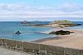
View of Grand Bé and Petit Bé

Both islands at sunset


literature
- Guillaume Lécuillier: La route des fortifications en Bretagne et Normandie , Les Éditions du Huitième Jour, Paris 2006, ISBN 978-2-914119-66-5 .
Web links
Individual evidence
- ↑ entry no. PA00090811 in the Base Mérimée of the French Ministry of Culture (French).