
Piazza Vittorio Emanuele II (Rome)

The Piazza Vittorio Emanuele II (colloquially: Piazza Vittorio ) is a rectangular park-like square in the Esquilino district of the Italian capital Rome . The square is named after King Victor Emmanuel II . The dimensions are 316 × 174 meters. This makes the Piazza Vittorio Emanuele II the largest square in Rome.
Emergence
The square and the buildings that border it were built in the new capital between 1882 and 1887, in the era after the unification of Italy (see Risorgimento ). The architect in charge was the Roman Gaetano Koch . The square is surrounded by imposing city palaces with arcades . These are stylistically based on Renaissance palaces such as the Palazzo Farnese . The buildings are typical of the style of King Umberto I's era (Umbertian era).
The building site had previously been acquired by the city of Rome. In the course of the earthworks, extensive finds of human bones were made, remnants of the ancient Roman Esquillinian cemetery where slaves and convicted criminals were buried.
Archaeological monuments
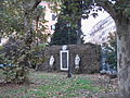
In the northwest part of the square is the Ninfeo di Alessandro ( Nymphaeum divi Alexandri ), also known as " Trofei di Mario ". It is an ancient monumental Roman fountain.
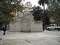
Also on the Piazza Vittorio is the so-called Porta Magica or Porta Alchemica . These are the remains of a 17th century portal of the residence of the alchemist Massimiliano Palombara.
The former market in Piazza Vittorio
On the Piazza Vittorio there was a large Viktualienmarkt with open market stalls, which was frequented by both Romans and tourists. The market, whose origins go back to the 19th century, was abandoned around the turn of the millennium in favor of the Nuovo mercato Esquilino .
gallery
Modern systems
Porta Magica

Remains of the monumental fountain


Web links
Individual evidence
- ↑ http://www.romasegreta.it/esquilino/piazza-vittorio-emanuele-ii.html
- ↑ http://www.romasegreta.it/esquilino/piazza-vittorio-emanuele-ii.html
- ^ Roberto Valentini, Giuseppe Zucchetti: Codice topografico della città di Roma. Rome 1940, volume I.
Coordinates: 41 ° 53 ′ 42.6 " N , 12 ° 30 ′ 17.1" E