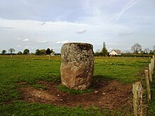
Pierre du Diable (Jullouville)
The Pierre du Diable ( German Teufelsstein ; also called Pierre Levée or Menhir de Vaumoisson ) is a menhir on the "Route de la Pierre au Diable" in the hamlet of Bouillon, east of Jullouville on the Cotentin peninsula in the Manche department in Normandy in France . It is one of several boulders , menhirs or dolmens with this name - also in the plural as "Les Pierres" (in Allinges, Arq, Artas, Beuvry, Jambes, Pierre du Diable (Haillot) , Pierre du Diable (La Garnache) , Layrisse, Pierre du Diable (Lécluse) , Soubise and Pierre du Diable (Vitrac) in Belgium, France and Switzerland).
The menhir is a granite block made of coarse-grained cylindrical granules with a flattened top. It is about 3.0 m high and has a circumference of 6 to 7 m. Its tip was broken off around 1820. The Archaeological Society of Avranches carried out excavations at the foot of the menhir in 1855 without making a discovery, but found that the menhir was founded to a depth of about 3.0 m in the ground, which indicates a great original length.
In the early 19th century, treasure hunters searching the ground around his foot were driven away by a person who wanted to murder them.
There was once a nearby Calvary, which was destroyed by a storm in 1855 and was probably built to drive out the devil.
See also
- Pierre du Diable (Haillot) , Belgium
- Pierre du Diable (Lécluse) , North Department
- Pierre du Diable (Vitrac) , Dordogne department
- Pierre du Diable (La Garnache) , Vendée department
- Menhir La Pierre au Diable , Mayenne department
literature
- Édouard Colin: Legends de Basse-Normandie. Inventaire communal. Charles Corlet, Condé-sur-Noireau / L'Orne en Français, Alençon 1992, ISBN 2-85480-404-X , p. 104.
- Jürgen E. Walkowitz: The megalithic syndrome. European cult sites of the Stone Age (= contributions to the prehistory and early history of Central Europe. Vol. 36). Beier & Beran, Langenweißbach 2003, ISBN 3-930036-70-3 .
Web links
- Description and pictures (English)
- Description and pictures (French)
Coordinates: 48 ° 46 ′ 21.4 " N , 1 ° 31 ′ 59.8" W.
