Playa Mayabeque
The Playa Mayabeque located 13 kilometers south of downtown Melena del Sur in the Cuban province of Mayabeque . Their waters are muddy and some of the area's residents attribute them medicinal properties.
history
According to historians, it was on this coast that the city of San Cristóbal de La Habana was first established in 1515, before moving to the north coast. That is why the Latin phrase "HIC PRIMO HABANA CONDITA EST" appears in the coat of arms of Melena del Sur ( this is where Havana was founded for the first time ).
vegetation
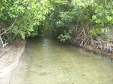
The vegetation consists mainly of mangroves and casuarinas . The latter threatened to disappear due to forest fires. There are other types of plants as well, including trees like coconut palms and almond trees .
water
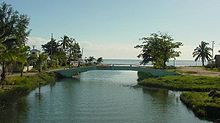
Several tributaries of the Río Mayabeque flow into Playa Mayabeque . The most important of these tributaries opens at the beginning of the beach; further tributaries flow through the area along the beach. The water in these rivers is mostly cold all day.
The whole length of the beach is muddy. This type of mud is said to have healing properties. In some parts of the beach there are often small colonies of termites that feed fish and other marine animals.
Population and infrastructure
The population density of the area is low. Only a few houses are inhabited all year round. The rest is used by fishermen for short stays.
The houses are usually made of wood or straw with guano roofs ; only a few are more solidly constructed. Nevertheless, due to their proximity to the beach, they are often partially or completely destroyed by tropical cyclones.
The beach is served by a cafeteria all year round; During the holiday season, the offer is more varied by government organizations and private owners who move to this area during the months of July and August.
Local transport is quite limited outside of the holiday season.
tourism
In summer, this beach is visited not only by swimmers from the area, but also from other places. The water of the rivers is particularly popular with children, the sea is of interest to swimmers.
In recent years there has been a tendency for the number of people involved in recreational fishing to increase, with the result that some rustic boats that serve that purpose have appeared.
Individual evidence
- ^ Fundación de La Habana a orillas del Río Onicajinal o Mayabeque
- ↑ San Cristóbal de La Habana en el Sur, Análisis histórico-geográfico de su Localisación, accessed on July 11, 2010
Coordinates: 22 ° 40 ′ 26.6 " N , 82 ° 8 ′ 48.7" W.


