Quessant
| Quessant | ||
|---|---|---|
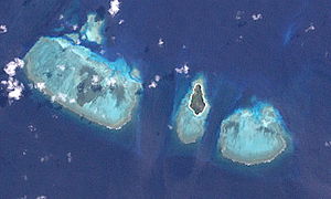
| NASA satellite image from Quessant | ||
| Waters | Solomon Lake | |
| Archipelago | Louisiade Archipelago | |
| Geographical location | 11 ° 9 '2 " S , 151 ° 15' 24" E | |
|
|
||
| length | 1 km | |
| width | 500 m | |
| surface | 50 ha | |
| Residents | uninhabited | |
Quessant (Tariwerwi or Ouessant) is an uninhabited coral island in the southeast of Papua New Guinea . It belongs to the Louisiade archipelago . Politically, it is part of the Milne Bay Province .
The Low Quessant lies on the northeast edge of a reef and is covered with thick vegetation . There are three more reefs between Quessant and the next, approx. 16 km northwest of the Stuers Islands .
Louis Antoine de Bougainville discovered the island on June 17, 1768 and named it because of its similarity after Ouessant , the French island near Brest , the starting point of his circumnavigation.
Individual evidence
- ↑ Louis Antoine de Bougainville: Voyage autour du monde, par la frégate du Roi La Boudeuse et la flûte L'Étoile , (Ed.): Jacques Proust, Gallimard, Paris 1990, p. 303 ISBN 2-07-037385-1 p 303

