Ría de Tina Mayor
| Ría de Tina Mayor | ||
|---|---|---|
|
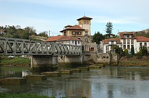
Outflow of the Río Deva in Unquera |
||
| Waters | Bay of Biscay | |
| Land mass | Iberian Peninsula | |
| Geographical location | 43 ° 23 '36 " N , 4 ° 30' 45" W | |
|
|
||
| width | a good 100 m | |
| length | 1.5 km | |
| surface | 82 ha | |
| Tributaries | Río Deva | |
The Ría de Tina Mayor is a ría in northern Spain between the autonomous communities of Spain Cantabria and Asturias or the Municipios Unquera and Ribadedeva , is formed by the estuary of the Río Deva and flows into the Bay of Biscay .
The total length from Unquera ( 43 ° 22 ′ N , 4 ° 31 ′ W ), where the Deva receives the name Tina Mayor, is one and a half kilometers, the width up to over 100 meters. The total area amounts to 82 hectares.
The ría, with its limestone banks sloping steeply in places, is navigable and has historically played a role in the removal of mining products such as zinc and sulfur.
The water is crossed by the Camino de la Costa ( European route 70 / Autopista AP-8 ). The regional road CA-380 runs on the east side.

