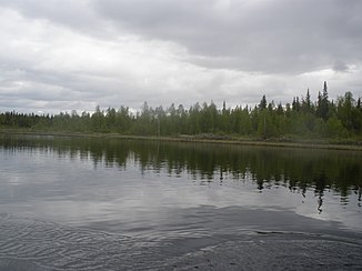
Raudanjoki
| Raudanjoki | ||
| Data | ||
| Water code | FI : 65.7 | |
| location | Lapland ( Finland ) | |
| River system | Kemijoki | |
| Drain over | Kemijoki → Baltic Sea | |
| source | southwest of Sodankylä 67 ° 18 ′ 28 ″ N , 26 ° 25 ′ 24 ″ E |
|
| muzzle | east of Rovaniemi in the Kemijoki Coordinates: 66 ° 28 ′ 0 ″ N , 26 ° 5 ′ 0 ″ E 66 ° 28 ′ 0 ″ N , 26 ° 5 ′ 0 ″ E
|
|
| length | approx. 150 km | |
| Catchment area | 3585 km² | |
| Flowing lakes | Yli-Nampajärvi , Ala-Nampajärvi , Vikajärvi , Alaselkä | |
The Raudanjoki is an approximately 150 km long right tributary of the Kemijoki in the Finnish landscape of Lapland .
The catchment area of the Raudanjoki lies north of the Kemijoki between Kemijärvi and Rovaniemi . It covers an area of 3585 km².
The Raudanjoki flows mainly in a southerly direction. In its lower reaches it flows through several larger lakes: Yli-Nampajärvi , Ala-Nampajärvi , Vikajärvi , Alaselkä . A few kilometers before its confluence with the Kemijoki, east of Rovaniemi, is the Permantocosque hydropower plant operated by Kemijoki Oy . It was built in 1960–61, has an installed capacity of 13 MW and uses a gradient of 24 m.
Individual evidence
- ↑ Kemijoki Oy - Permantokosken Voimalaitos ( Page no longer available , search in web archives ) Info: The link was automatically marked as defective. Please check the link according to the instructions and then remove this notice. (PDF; 412 kB)
