Republiek (Suriname)
| Republiek | ||
|---|---|---|
|
Coordinates: 5 ° 30 ′ N , 55 ° 12 ′ W Republiek on the map of Suriname
|
||
| Basic data | ||
| Country | Suriname | |
| District | Para | |
| Residents | 50 | |
| Detailed data | ||
| height | 14 m | |
| Waters | Coropinakreek | |
| Time zone | UTC −3 | |
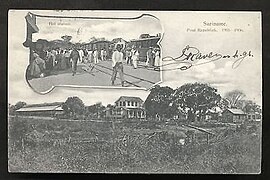
| Post Republiek and stop at Lawaspoor 1905 | ||
| Republiek military post around 1890 | ||
Republiek is a place in the Para-Zuid resort, Para district , in Suriname .
history
Republiek was originally a military post on the Coropinakreek, established in the first half of the 19th century. It was on the borders of the Mijn Hoop and Valkenburg wood plantations . After slavery was abolished in 1863 by the colonial power, the Kingdom of the Netherlands , former slaves bought the plantations in 1884.
railroad
With the construction of the Lawabahn , Republiek was also connected to the railway network from 1905 with a stopping point and thus with the capital Paramaribo . In the long dry season, the railway was also used as a means of transport to supply the residents of Paramaribo with water from Para, from the Republiek station. The photo on the left shows the supply of water from Republiek to the residents of Paramaribo at the covered market Heiligenweg during the great dry season in 1912.
Thanks to the railway, the former plantation area in the Para district with its streams was popular early on as a destination for excursions and a place to relax with capital city dwellers.
Water company
In 1933, a water extraction company with a water treatment plant and pumping station was set up in Republiek . Since then, the Surinaamsche Waterleiding Maatschappij has been leading the high-quality water to the surrounding districts and Paramaribo by means of water pipes.
literature
- CFA Bruijning and J. Voorhoeve (red.): Encyclopedie van Suriname . Elsevier , Amsterdam a. Brussel 1977, ISBN 90-10-01842-3 , p. 531.
Individual evidence
- ^ Website Plantation Board Dutch, accessed on March 27, 2016


