Ring Canal (Hamburg)
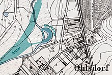
The ring canal in Hamburg - Ohlsdorf is an oxbow lake of the Alster . It is 270 meters long and up to 30 meters in the upper part and 10 meters wide in the lower part. An approximately 1800 square meter tree-lined island lies in the water.
The former course of the Alster was straightened from 1913 to around 1918 from Ohlsdorf to Winterhude . On the west side of the then newly built Ohlsdorf train station, a part of the old course that was separated at the top remained. A footbridge spans the lower end.
The ring canal is a first-order body of water. A barrier at the confluence with the Alster prevents canoes from entering.
Web links
Commons : ring channel - collection of images, videos and audio files
proof
- ↑ Geoportal Hamburg , accessed on November 7, 2019
- ↑ Sven Bardua: Fuhlsbüttel lock threatened with demolition! , Willi-Bredel-Gesellschaft - Geschichtswerkstatt eV, circular 2010, p. 39
- ↑ Hamburg Water Act (HWaG) in the version of March 29, 2005 , accessed on November 7, 2019
Coordinates: 53 ° 37 '12 " N , 10 ° 1' 45" E

