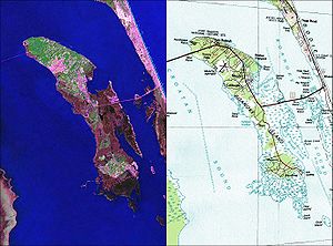
Roanoke Island
| Roanoke | ||
|---|---|---|
| NASA Geocover 2000 Satellite Image and USGS Topographic Map | ||
| Waters | Albemarle Sound , Atlantic Intracoastal Waterway | |
| Geographical location | 35 ° 53 ′ N , 75 ° 39 ′ W | |
|
|
||
| length | 16 km | |
| width | 4.3 km | |
| surface | 46.48 km² | |
| Highest elevation | 22.6 m | |
| Residents | 6724 (2000) 145 inhabitants / km² |
|
| main place | Manteo | |
Roanoke [ ˈɹɔɘˌnɔɘk ] Island is an island on the US coast of North Carolina . The name comes from the local Algonkindialect . On the one hand, the first English settlement in North America was located here, and on the other hand, the island is known for the mysterious disappearance of over 100 English colonists towards the end of the 16th century.
geography
The 16 km long and 4.3 km wide island with an area of 46.48 km² is located in the passage from Albemarle Sound to Pamlico Sound in the sound off the coast of North Carolina, separated from the Atlantic by the Outer Banks . It belongs to North Carolina's Dare County and is connected to the mainland and Bodie Island via US Highway 64 . The largest settlements are Manteo in the north and Wanchese in the south of the island. Manteo is the capital of the island as well as the entire Dare County. Wanchese does not have its own administration, but is administered by Dare County. The total population was 6,724 according to the 2000 US census.

