Roubidoux Spring
| Roubidoux Spring | |||
|---|---|---|---|
 Roubidoux Spring |
|||
| location | |||
| Country or region | Pulaski County , Missouri ( United States ) | ||
| Coordinates | 37 ° 49 ′ 30 ″ N , 92 ° 12 ′ 5 ″ W. | ||
|
|||
| geology | |||
| Mountains | Ozark Mountains | ||
| Source type | Karst spring | ||
| Hydrology | |||
| River system | Mississippi River | ||
| Receiving waters | Roubidoux Creek → Gasconade River → Missouri River → Mississippi River → Gulf of Mexico | ||
| Bulk | 1650 l / s | ||
Coordinates: 37 ° 49 ′ 30 ″ N , 92 ° 12 ′ 5 ″ W.
The Roubidoux Spring is a karst spring in the state of Missouri in the United States .
description
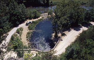
The source is located in Pulaski County south of Waynesville . It rises at the foot of a rock that was covered with a large concrete wall for the construction of a road. The water flowing from the Roubidoux Spring flows into the Roubidoux Creek after a few meters. A footpath on a wooden walkway was built around the spring. The karst spring pours an average of 1650 l / s. The area near the source has very intense landforms in Karst with many caves and springs.
See also
Web links
Commons : Roubidoux Spring - Collection of images, videos and audio files
Individual evidence
- ↑ Vineyard and Federer, 1982, p. 94


