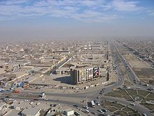
Sadr City
Sadr City (German Sadr-Stadt ; Arabic مدينة الصدر الثاني Madīnat as-Sadr ath-thānī , DMG Madīnat aṣ-Ṣadr aṯ-ṯānī ) is a northeastern district of Baghdad in Iraq . It is bounded to the west by the Army Canal and to the east by another canal. Imam Ali Street and Umar bin Khalab Street border the district in the south.
It was named the City of Revolution in 1959 after the overthrow of the monarchy by the new Prime Minister Abd al-Karim Qasim (مدينة ألثورة Madīnat ath-Thaura , DMG Madīnat aṯ-Ṯawra ). Shiites , inparticular, whowere persecutedunder the later Saddam Hussein regime, settled in this district. After Saddam Hussein came to power, the district was unofficially in Saddam City (مدينة صدام Madīnat Saddām , DMG Madīnat Ṣaddām ) renamed. The official renaming followed in 1982. After the invasion of Baghdad by coalition forces in 2003, the influence of the old regime suddenly ended. Paramilitaries of the radical Iraqi Shiite leader Muqtada al-Sadr managed to increase their influence in the district. The district was finally renamed in the spring of 2003 after Grand Ayatollah Muhammad Muhammad Sadiq as-Sadr - the father of Muqtada as-Sadr and opposition to Saddam Hussein - in Madīnat as-Sadr ath-thānī . About two million people currently live in the district. Until 2008, Sadr City represented one of the greatest security risks for the American occupation forces.
A Joint Security Station of the Iraqi armed forces and the police is located in Sadr City .
literature
- Marc Thörner : Iraq. From Saddam City to Sadr City. The Iraqi Shiites . Lamuv Verlag , Göttingen 2005, ISBN 978-3889776587 .
Individual evidence
- ↑ Behnam Said : Muqtada as-Sadr - selected examples of his ideology in 2003 , GRIN Verlag, Munich and Ravensburg 2008, ISBN 3638918580 , p. 9
- ^ Marion Farouk-Sluglett, Peter Sluglett: Iraq since 1958: From Revolution to Dictatorship , London, 2003, p. 263
- ↑ http://www.understandingwar.org/region/baghdad-city
Coordinates: 33 ° 23 ' N , 44 ° 27' E

