San Juan Bautista Tuxtepec
| San Juan Bautista Tuxtepec | ||
|---|---|---|
|
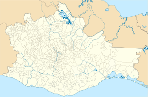
Coordinates: 18 ° 5 ′ N , 96 ° 7 ′ W San Juan Bautista Tuxtepec on the map of Oaxaca
|
||
| Basic data | ||
| Country | Mexico | |
| State | Oaxaca | |
| Municipio | San Juan Bautista Tuxtepec | |
| Residents | 101,810 (2010) | |
| City insignia | ||
| Detailed data | ||
| Waters | Río Papaloapan | |
| Website | ||
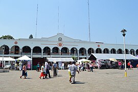
| Palacio Municipal | ||
San Juan Bautista Tuxtepec (short: Tuxtepec ) is a city in southern Mexico . The city is inland. About 100,000 people live in the city. Tuxtepec is the second largest city in the state of Oaxaca . Their name is derived from the Nahuatl word tōchtepēc (German: "in the rabbit hill ").
location
Tuxtepec is located in the north of the state of Oaxaca. The city is crossed by the Río Papaloapan and lies at an altitude of 20 meters. About 20 km west of the city is the Miguel Alemán reservoir . In 1944, a four to nine meter high tidal wave from the Río Papaloapan killed many people. In 1969, another flood hit the city , followed by the great earthquake with the epicenter in Michoacán in 1985 .
history
The modern settlement was founded in 1811 and made a town in 1825. In 2012, the remains of a large Aztec settlement were discovered. In the 1980s, the city, which until then had been a center of wood processing, experienced an upswing with the establishment of a large brewery and the Instituto Tecnológico de Tuxtepec .
religion
94% of the population of Tuxtepec is Catholic . In 1979 Pope John Paul II created the Tuxtepec diocese , which still exists today and is home to 688,000 Catholics. The seat of the diocese is the Cathedral of San Juan Batista in Tuxtepec.
Individual evidence
- ^ Catálogo de Localidades
- ↑ Google Maps. Retrieved March 27, 2017 .


