Sanders Island
| Sanders Island | ||
|---|---|---|
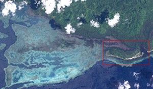
| NASA Landsat image of Sanders Island (framed in red). | ||
| Waters | Bismarcksee | |
| Archipelago | Admiralty Islands | |
| Geographical location | 2 ° 12 '15 " S , 147 ° 10' 48" E | |
|
|
||
| length | 1.9 km | |
| width | 400 m | |
| surface | 70 ha | |
| Residents | uninhabited | |
Sanders Island is an uninhabited island of Papua New Guinea in the Admiralty Islands archipelago .
The densely forested island is located directly in front of the southeast coast of the island of Manus , only separated from the mainland by a narrow and thickly mangrove canal. About 2 km northwest of Sanders are the Awulu Islands .

