Santon Downham Tramway
| Santon Downham Tramway Downham Hall Timber Railway |
||||||||||||||||||
|---|---|---|---|---|---|---|---|---|---|---|---|---|---|---|---|---|---|---|
|
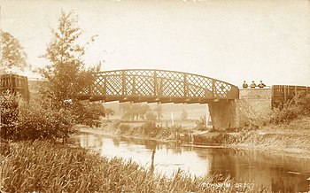
Cast iron bridge at Santon Downham
| ||||||||||||||||||
|
Probable route
| ||||||||||||||||||
| Route length: | 6 km | |||||||||||||||||
| Gauge : | 914 mm ( English 3-foot track ) | |||||||||||||||||
|
||||||||||||||||||
The Santon Downham Tramway or Downham Hall Timber Railway was a 1918 run to about 1,922, 6 km long narrow gauge - forest railway with a track width of 914 mm at Santon Downham near Thetford in England.
history
The Canadian Army operated a total of 89 sawmills in Great Britain and France during World War I. Together with the British Pioneer Corp, they laid the forest railway line at Santon Downham for the Home Grown Timber Board, part of the Ministry of Supply, during the First World War. The sawmill was put into operation on July 27, 1918. In the second half of 1918, 1,244 cubic meters (43,940 cubic feet, 527,289 FBM ) of sawn timber were extracted there. The line was privatized after the war and dismantled in the late 1920s.
Route
The forest railway had a track width of 914 mm (3 feet ). The 3.5 km long main line ran from the sawmill on the standard gauge Cambridge - Norwich railway to the High Lodge and a 2.5 km branch line to Little Lodge Farm. The route is not shown on historical maps, so there are four different theories about its route.
The sawmill was on a siding southwest of the standard-gauge line, on which a creosote plant was built in 1947 . The line led from there over a cast-iron bridge made by Stockton MI Co. Iron , which was temporarily reinforced for the forest railway operation by a support pillar attached in the middle. The engine shed was next to the post office.
A turntable at the school building served the branch line that ran east along the river valley to Little Lodge Farm near Two Mile Bottom. The main line ran west through the village to Woodcock Cottage, where it turned south, presumably using another turntable, and ran on flat terrain and around the hill to the southwest of the village to the High Lodge.
Rail vehicles
There were three Bagnall locomotives with the serial numbers 2081, 2085 and 2086. These two-axle B 2nt saddle tank locomotives each had two cylinders with a displacement of 178 × 305 mm (7 × 12 inches) bore × stroke. Their wheels were 546 mm (21½ inches) in diameter. The locomotive with the factory number 2081 was delivered by Bagnall to the Ministry of Munitions OC 126 Company Canadian Forestry Corps Downham Hall Brandon Suffolk in February 1919 and sold in 1922 by the Board of Trade. The locomotives with the serial numbers 2085 and 2086 were identical to the number 2081 and were delivered by Bagnall in March 1919 to the technical department store of the Canadian Forestry Corps ( Minister of Militia and Defense , MofM) in the London borough of Bellingham .
Individual evidence
- ↑ a b c d e Newly discovered forest tramway.
- ↑ a b c d D. Manning: The Bridge. Santon Downham History.
- ↑ a b Timber Railway. Santon Downham History.
- ^ A b Friends of Thetford Forest: The Hidden Heritage of High Lodge - The Light Railway at High Lodge. With 3 alternative route plans.
- ^ John Rayment: The Hidden Heritage of High Lodge - Canadians on the Downham Estate. 2019.
- ^ CW Bird and JB Davies: The Canadian Forestry Corps; its inception, development and achievements. Prepared by request of Sir Albert H. Stanley. 1919. p. 28.
- ^ CW Bird and JB Davies: The Canadian Forestry Corps; its inception, development and achievements. Prepared by request of Sir Albert H. Stanley. 1919. p. 33.
- ↑ Ordnance Survey: Norfolk XCIII.SW (including: Lynford, Santon Downham; Weeting with Brome Hill.) 1926-1929.
- ↑ Ordnance Survey: Norfolk CII.NW (including Brandon, Santon Downham, Thetford.) 1926-1929.
- ↑ a b Barry Griggs: Santon Downham's Narrow-Gauge Railway. FCA Today, Issue 28, March 2006.
- ^ David Cox and Christopher Krupa: The Kerry Tramway and other Timber Light Railways. 1992, p. 59.
Coordinates: 52 ° 27 ′ 28.3 " N , 0 ° 40 ′ 18.3" E

