
Ship settlement at Gnisvärd

The ship settlements at Gnisvärd ( Swedish Skeppsättningar also Ansarve hage - Tofta 14: 1 and Tofta 15: 1) are in the parish of Tofta on the Swedish island of Gotland between the church of Tofta and the fishing port of Gnisvärd on the west coast of the island. They come from the late Bronze Age . The ship's settlements are among the best preserved on Gotland.
Gnisvärd 1 is 47 meters long and 7 meters wide and is the largest ship on Gotland. It consists of about 100 closely lined up, erect stones. The stern and stern are about 1.3 meters taller than the rest of the ship. The ship setting is surrounded by two smaller round stone settings. Nearby is the Toftadösen dolmen .
About 100 meters further south is Gnisvärd 2, another large ship that is 36 meters long and 4 meters wide. Apart from the bow and stern sides, the stones are much smaller and barely protrude 30 cm from the ground. Also, this reduction vessel is of two smaller round stone settings and Röse surrounded with a diameter of 16 meters and other smaller and less well-preserved ship translations.
About 200 meters east of it is a burial ground , which consists of a grave loop and eight round stone settings. Another large grave monument in Gnisvärd is another roe, which lies between the ship settlements and the fishing village of Gnisvärd. It has a diameter of 23 meters and a height of 2.7 meters.
photos
- Ship settlements and dolmens at Gnisvärd
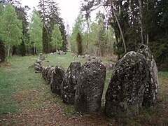
View from the path to one of the ship settlements

View of the path over one of the ship settlements

Ship settlement at night

Runestone

Gnisvärd dolmen


See also
Individual evidence
- ↑ FMIS Tofta 14: 1. In: Riksantikvarieämbetet . Retrieved January 8, 2012 .
- ↑ FMIS Tofta 15: 1. In: Riksantikvarieämbetet. Retrieved January 8, 2012 .
- ↑ FMIS Tofta 17: 1. In: Riksantikvarieämbetet. Retrieved January 8, 2012 .
- ↑ FMIS Tofta 19: 1. In: Riksantikvarieämbetet. Retrieved January 8, 2012 .
- ↑ FMIS Tofta 12: 1. In: Riksantikvarieämbetet. Retrieved January 8, 2012 .
Web links
- Skeppsättningar i Ansarve hage. In: guteinfo.com. Retrieved on February 16, 2012 (Swedish, ship setting at Gnisvärds in text and images).
- The Megalithic Portal (English)
- Ship placement 1
- Ship placement 2
Coordinates: 57 ° 30 ′ 30 ″ N , 18 ° 8 ′ 27 ″ E