
Schillingstrasse (Berlin)
| Schillingstrasse | |
|---|---|
|
|
|
| Basic data | |
| place | Berlin |
| District | center |
| Created | around 1723 |
| Hist. Names | Schillinggasse (around 1723 to around 1737 ) Schmelzens Gasse (around 1737 – around 1770) Schillinggasse (around 1770–1858) |
| Cross streets | Jacobystraße, Magazinstraße, Singerstraße (from north to south) |
| use | |
| User groups | Pedestrian traffic , bicycle traffic , car traffic |
| Technical specifications | |
| Street length | 480 meters |
The Schillingstraße is a street in the Berlin district of Mitte of the district of the same . It runs from Karl-Marx-Allee to Alexanderstraße . A striking building on the corner of Karl-Marx-Allee is Café Moskau .
history
The street was named after the Berlin merchant Philipp Andreas Schilling (around 1650–1714), whose family owned land in the area. Until 1858 it was called Schillinggasse and was then elevated to a street, "because the street was widened and then embellished."
The Schillingstrasse underground station on today's U 5 line was opened on December 21, 1930. Since the rebuilding of Karl-Marx-Allee in the early 1960s, the south-eastern subway entrance has been incorporated into a corner building on Schillingstrasse.
In 1962 an outpatient clinic was opened in the street , in 1966 the 17-storey high-rise building with 240 one-room apartments at the confluence with Singerstraße was completed. In the same year came consumption - Market Hall and the club restaurant "dots". With the new development, pedestrian promenades and raised beds were created.
Until the early 1960s, Schillingstrasse ended at Blumenstrasse . This was abandoned and its last section up to Alexanderstrasse was included in Schillingstrasse. A footpath connects the southern Schillingstrasse with the S-Bahn station Jannowitzbrücke on the Stadtbahn .
photos

Looking north towards Karl-Marx-Allee (1965)
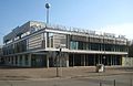
Cafe Moscow
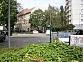
View from Schilling Street to Magazin Street

Skyscraper Schillingstraße 30
(type WHH 17)


.jpg)

Web links
Individual evidence
- ^ Kaupert's city guide: Schillingstrasse. Retrieved July 23, 2020 .
- ↑ Handover of the new city clinic. In: Neues Deutschland , December 8, 1962, p. 6.
- ↑ Over the roofs of Berlin. In: Neue Zeit , September 13, 1966, p. 6.
Coordinates: 52 ° 31 ′ 3.4 " N , 13 ° 25 ′ 13.1" E