
Shokanbetsu-Teuri-Yagishiri-Quasi-National Park
|
Shokanbetsu-Teuri-Yagishiri-Quasi-National Park
|
||
 Uryū Marshland and Mashike Mountains in the background |
||
| location | Hokkaidō , Japan | |
| surface | 435.59 km² | |
| WDPA ID | 29811 | |
| Geographical location | 43 ° 0 ′ N , 141 ° 0 ′ E | |
|
||
| Setup date | August 1, 1990 | |
| administration | Hokkaido Prefecture | |

The Shokanbetsu-Teuri-Yagishiri quasi-National Park ( Jap. 暑寒別天売焼尻国定公園, Shokanbetsu-Teuri-Yagishiri Kokutei Kōen ) is a Quasi-National Park in the region of Hokkaido in Japan . The park, founded on August 1, 1990, covers an area of approx. 436 km². The quasi-national park is divided into three separate areas:
- Mashike mountains, especially Shokanbetsu (1492 m) - from the coast up to approx. 30 km inland
- The island pair Yagishiri-tō and Teuri-tō about 70 km further north
- an approx. 15 km long section of steep coast further south (Cape Ofuyu)
With the IUCN Category V, the park area is classified as a Protected Landscape / Protected Marine Area . The Hokkaidō Prefecture is responsible for the management of the park.
gallery

Shokanbetsu ( Japanese 寒 別 岳 , Shokanbetsu-dake ) mountain as seen from Minamishokandake
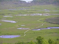
Uryū marshland ( Japanese 雨 竜 沼 , Uryū-numa , "rain dragon")
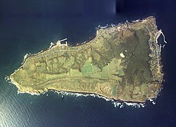
The island of Yagishiri ( Japanese 焼 尻 島 , Yagishiri-tō ) from the air

The island of Teuri ( Japanese 天 売 島 , Teuri-tō ) from the air
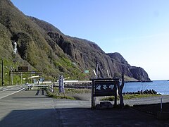
Cape Ofuyu ( Japanese 雄 冬 岬 , Ofuyu-misaki )


