
Seepage line

A seepage line is the boundary between dry and moist material in a dam or dike that is dammed with water on one side and not on the other.
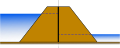
The seepage line connects the water level on the dammed side ( water side ) with the water level, groundwater level (if available) or the top of the ground on the non-dammed side, the air side. The seepage line can emerge at the dam foot on the air side and thus become visible in the form of seepage water. In the case of a homogeneous dam, the seepage line emerges on the air side at approximately a third of the dam height, as shown in the picture (according to the theory of Arthur Casagrande ). Dam construction material can be flushed out below this point, which can endanger the stability of the dam or dike.
If the water level rises, the seepage line in the dam also rises. If it falls again, the drainage line also sinks. The rise and fall of the seepage line usually do not happen as quickly as the water level rises or falls, but rather gradually, which means that these processes are transient . If the water level remains the same, a constant seepage line will appear after a while. The more impermeable the dam, the longer it takes for the seepage line to become constant because the water first has to seep through the material. The higher the seepage line, the lower the stability . This happens, for example, with dikes when there is high water.
In the case of a homogeneous dam, the seepage line does not depend on the permeability of the material used, but solely on the geometry. The permeability of the dam only determines the flow.
In the inhomogeneous case, however, the permeability of the dam and its different areas plays a role. In the case of a dam that is denser (more impermeable) on the water side than in the rest of the area, the seepage line is drawn down in the denser area and then no longer emerges on the air side, which significantly increases the stability. That is why it makes sense to seal dams and dykes on the water side and drain them on the air side through more permeable filter layers.
Drainage lines at different types of dams

homogeneous dam

homogeneous dam with kink contour
Dam with impermeable inner membrane

Dam with inner seal

Dam with outer seal
further reading
- Leaflet ATV-DVWK-M 502: Calculation method for dams - interaction between structure and subsoil, March 2002, ISBN 978-3-935669-44-3
Web links
- Instructions for the defense of river dykes, dams and small dams; there page 11ff (PDF file; 2.00 MB)
- Introduction to hydraulic engineering and water management Here you can see drainage lines on p. 21. (PDF file, 629 kB)