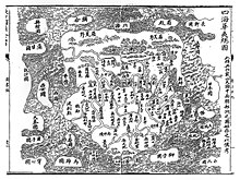
Sihai Huayi Zongtu
The Sihai Huayi Zongtu map ( Chinese 四海 華 夷 總 圖 / 四海 华 夷 总 图 - "Overview map of China and the barbarians of the four seas") is an old Chinese map of the world that is currently in the library of Harvard University . It dates from 1532, i.e. from the Ming Dynasty .
The map shows China , Korea ( 朝鮮 ) and Japan ( 日本國 ) in the east, Siberia ( 羅 荒野 ) in the north, Nepal ( 天竺 ) and a huge India ( 印度 ) in the south, Persia ( 波 刺 斯 ) in the west and that Roman Empire ( 大 秦國 , Daqinguo ) across the western sea ( 西海 ).
