Smědavská hora
| Smědavská hora | ||
|---|---|---|
|
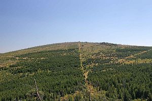
View of the Wittigberg |
||
| height | 1083.9 m | |
| location | Czech Republic | |
| Mountains | Jizera Mountains | |
| Coordinates | 50 ° 51 '1 " N , 15 ° 14' 43" E | |
|
|
||
The Smědavská hora (German Wittigberg , also Rollberg) is a 1083.9 m high mountain in the Jizera Mountains , south of Bilý Potok (Weißbach) . The German and the Czech name refer to the river Wittig ( Smědá ), which rises as the White Wittig ( Bílá Smědá ) in the peat bogs below the southern slope of the mountain. The Wittighaus ( Smědava ) mountain hut is located below the mountain .
About 700 meters south-east of the summit is the Wolf Meadow ( Vlčí louka ) natural monument , which protects one of the highest raised bogs in the Jizera Mountains. In the vicinity of the monument in the south are the other natural monuments U posedu, Klečové louky, Kneipe ( Na Kneipě ) and the nature reserve Prales Jizera am Siechhübel.
To the northwest of the summit are the Mittagssteine ( Pohledi Kameni ), to the southeast of the Jizera ( Siechhübel ). The eastern neighboring mountains of the Wittigberg are the pigeon house ( Holubník ) and the Vogelkoppen ( Ptačí kupy ). In the southwest of the Wittigberg are the snow towers ( Sněžné věžičky ) and the Černá hora ( Schwarzenberg ).
Web links
Individual evidence
- ^ Austro-Hungarian review . tape 26 . Publishing house of the Austro-Hungarian Review, 1900, p. 294 .

