
South Harbor (Nova Scotia)
| South harbor | |||
|---|---|---|---|
| Location in Nova Scotia | |||
|
|||
| State : |
|
||
| Province : | Nova Scotia | ||
| County: | Victoria County | ||
| Coordinates : | 46 ° 52 ′ N , 60 ° 28 ′ W | ||

South Harbor ( English for "Haven") is a small community in the Canadian province of Nova Scotia , in the Aspy Bay region is Victoria County on Cape Breton Iceland .
The community borders the Cape Breton Highlands National Park in the south.
geography
Actually, South Harbor is a misnomer - the only exit from the body of water is a canal, through a sandbar into the sea, and is too small for commercial craft to cross. The sandbar is narrow enough that the salty sea water enters the port, so the port's water is brackish. That is why the body of water is actually an estuary . The canal is periodically closed and reopened, and moves location up and down the sandbar. The two main bays of South Harbor are Effie's Bach and Glasgow Bach.
economy
As with many communities on Cape Breton Island, fishing and tourism are the main sources of income for residents. Oysters and clams are harvested in the port. A variety of seasonal accommodations are available for visitors, and there are many options for outdoor activities such as canoeing, kayaking, hiking, swimming, and sailing in and around the community.

South Harbor in summer
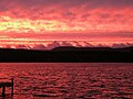
Sunset over South Harbor
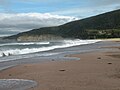
South Harbor beach in summer

South Harbor in autumn

South Harbor in winter

South Harbor on a calm day
_in_the_summer.jpg)
.jpg)
_Beach_in_the_summer.jpg)
_in_the_autumn.jpg)
_in_the_winter.jpg)
_on_a_calm_day.jpg)
Web links
- South Harbor on Destination Nova Scotia