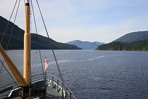
Sproat Narrows
| Sproat Narrows | ||
|---|---|---|
| Connects waters | Alberni Inlet | |
| with water | Alberni Inlet | |
| Separates land mass | Vancouver Island | |
| of land mass | Vancouver Island | |
| Data | ||
| Geographical location | 49 ° 6 ′ 56 ″ N , 124 ° 49 ′ 0 ″ W | |
|
|
||
The Sproat Narrows are a strait in Alberni Inlet on Vancouver Island in the Canadian province of British Columbia . It is located near River Point , Hocking Point, and Chuchakacook Indian Reserve 4 . Macktush Bay is also nearby . The Franklin River flows into the straits. The estimated elevation of the terrain is one meter above sea level.
history
The name Sproat Narrows as the name for the strait was officially adopted on August 13, 1945 following the recommendation of the "Hydrographic Service". The name First Narrows , as it is used in maps and documents from 1867 and 1929, became obsolete. The part of the name Sproat goes back to the Scottish-born Canadian businessman Gilbert Malcolm Sproat (1834-1913), who is also the namesake of Sproat Lake.
The Sproat Narrows were also affected by the great Good Friday quake in 1964 . Both beacons that mark the respective bank were destroyed. A telephone cable in the Alberni Inlet was also destroyed.
Web links
- Sproat Narrows . In: BC Geographical Names (English)
Individual evidence
- ^ Sproat Narrows. mapcarto.com, accessed October 25, 2016 .
- ^ Sproat Narrows. geoview.info, accessed October 25, 2016 .
- ^ Sproat Narrows . In: BC Geographical Names (English)
- ↑ Sproat Lake . In: BC Geographical Names (English)
- ^ Committee on the Alaska Earthquake of the Division of Earth Science National Research Council: The Great Alaska Earthquake of 1964 . National Academy of Science, Washington DC 1972, ISBN 0-309-01605-3 , pp. 481 . (American English).

