
Stac Levenish
| Stac Levenish | ||
|---|---|---|
 |
||
| Waters | North Atlantic | |
| Archipelago | St. Kilda | |
| Geographical location | 57 ° 47 '29.4 " N , 8 ° 30' 39.6" W | |
|
||
| length | 190 m | |
| width | 140 m | |
| surface | 2,428 ha | |
| Highest elevation | 62 m | |
| Residents | uninhabited | |

Stac Levenish ( Scottish Gaelic Stac Leibhinis ; often just called Levenish ) is a rock needle in the St. Kilda archipelago in the North Atlantic and politically belongs to Scotland . The island has an area of approximately 24,280 m² . As part of the St. Kilda archipelago, the Stac is a UNESCO World Heritage Site .
Stac Levenish is about 4 km east of the main island of Hirta . To the northeast of the rock lies the tiny Na Badhan archipelago . On the north coast of Stac Levenish one can make out the profile of a human face visible from the east.
The rock rises steeply from northeast to southwest. In the southwest is the highest point of the rock needle at 62 meters above sea level. In the early 20th century, the rock was frequently climbed by recreational rock climbers. There was a climb, in addition Stac Levenish also Stac Lee included. The climb to Stac Levenish has been rated as moderate.

The "face" of Stac Levenish
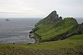
Dùn with Stac Levenish in the background

Topographic map of the archipelago with Stac Levenish (bottom right)


Web links
- ↑ St. Kilda - Wild Isles on the Edge of the World (English)
- ^ Norman Heathcote: Climbing in St Kilda. In: Scottish Mountaineering Club Journal. Vol. 6, No. 5, 1901, ZDB -ID 1453959-7 , pp. 146-151, ( online ).
Islands: Boreray | Dùn | Hirta | Soay
Sea stacks (rocks): Stac to Armin | Stac Biorach | Stac Lee | Stac Levenish