Reservoir community
| coat of arms | map |
|---|---|

|

|
| Basic data | |
| State : |
|
| Coordinates : | 49 ° 54 ' N , 5 ° 52' E |
| Canton : | Wiltz |
| Residents : | 1952 (January 1, 2019) |
| Area : | 48.5 km² |
| Population density : | 40.2 inhabitants / km² |
| Municipality number: | 0806 |
| Website: | www.lac-haute-sure.lu |
| politics | |
| Mayor: | René Michels |
| Elective system : | Majority vote |
The reservoir municipality ( Luxembourgish Stauséigemeng , French Commune du Lac de la Haute-Sûre ) is a municipality in the Grand Duchy of Luxembourg and belongs to the canton of Wiltz .
The community, which is located on both banks of the Obersauer reservoir on the upper reaches of the Sauer , was created on January 1, 1979 through the merger of the communities Mecher and Harlingen. The parish hall is located in Böwen.
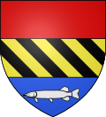
coat of arms
Blazon : "The three-part coat of arms has a single red field at the top , a golden one with four black right-angled bars in the middle and a silver pike at the bottom in blue ."
Composition of the community
The Lac de la Haute-Sûre commune consists of the following localities:
- Boewen (Bavigne)
- Harlingen (Harlange)
- Kaundorf
- Liefringen (Liefrange)
- Mecher
- Nothum
- Ischpelt (Tarchamps)
- Walter (Watrange)
Web links
Commons : Reservoir - collection of images, videos and audio files
- Reservoir municipality website
- Data sheet of the municipality (PDF; 24 kB) on the Syvicol website