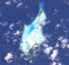
Strathord Islands
| Strathord Islands | ||
|---|---|---|
| Strathord Islands | ||
| Waters | Solomon Lake | |
| archipelago | Bonvouloir Islands ( Louisiade Archipelago ) | |
| Geographical location | 10 ° 15 ′ S , 151 ° 52 ′ E | |
|
|
||
| Number of islands | 5 | |
| Main island | Strathord Island | |
| Total land area | 1.34 km² | |
| Residents | uninhabited | |
The Strathord Islands are an uninhabited group of islands in the Solomon Sea . Politically, they belong to the Milne Bay province in the southeastern area of Papua New Guinea .
The islands are located about 100 km northwest of Misima and form the northernmost group of the Louisiade archipelago . They belong to the Bonvouloir Islands , which also include Hastings Island, about 9 km south, and East Island , about 30 km southeast .
The main island Strathord Island is located on the southern reef rim of the group, is densely forested and flat.
Islands
![]() Map with all coordinates: OSM | WikiMap
Map with all coordinates: OSM | WikiMap
| Surname | Coordinates | Area km² |
|---|---|---|
| North Island | 10 ° 13 ′ 29 ″ S, 151 ° 52 ′ 1 ″ E | 0.18 |
| Middle Island | 10 ° 14 ′ 13 ″ S, 151 ° 51 ′ 51 ″ E | 0.08 |
| Amanuta | 10 ° 14 ′ 32 ″ S, 151 ° 51 ′ 41 ″ E | 0.05 |
| ( unnamed ) | 10 ° 15 ′ 17 ″ S, 151 ° 50 ′ 59 ″ E | 0.04 |
| Strathord Island | 10 ° 15 ′ 22 ″ S, 151 ° 51 ′ 36 ″ E | 0.99 |

