Sultantepe
Coordinates: 37 ° 3 ′ 1 ″ N , 38 ° 54 ′ 22 ″ E
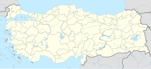
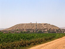
The Sultantepe is a mighty tell near today's city of Şanlıurfa in southeastern Turkey, on the route to Harran , which rises around 50 meters above the surrounding Harran plain . Sultantepe is known for its late Assyrian settlement, in which it probably bore the name Ḫuzirina , especially as a place of worship.
Excavations at Sultantepe took place in the 1950s under the direction of Seton Lloyd and Nuri Gökçe , with remains of an Assyrian city dating from the 8th and 7th centuries BC. Came to the fore. An extensive archive of cuneiform texts was found in the ruins of the city, which was presumably lost in a fire . The approximately 600 clay tablets belong to the most varied of genres and prove that the inhabitants of this Assyrian city had Aramaic names. The downfall of the city can be related to the conquest and destruction of neighboring Harran in 610 BC. Be brought.
literature
- Jacob J. Finkelstein: Assyrian Contracts from Sultantepe. In: Anatolian Studies 7, 1957, pp. 137-145.
- Seton Lloyd / Nuri Gökçe: Sultantepe: Anglo-Turkish Joint Excavations, 1952 , in: Anatolian Studies 3, 1953, pp. 27–47.
- Oliver R. Gurney / Jacob J. Finkelstein / P. Hulin: The Sultantepe tablets 1-2. London, 1957-1964.
Web links
- Study of the Sultantepe Tablets on the website of the British Institute at Ankara

