Sweet track
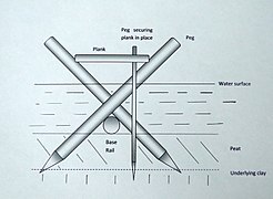
Discovered in the 1970s, the Sweet Track is a Neolithic boardwalk through a marshland in the Somerset Levels of Somerset in England . According to dendrological studies, it was created in 3807 or 3806 BC. The Sweet Track was part of a network of trails over swampy ground. It ran between an island in Westhay and a hill near the Bruce River.
The approximately 1.6 km long path was discovered in the 1970s during a peat extraction by Ray Sweet (who gave the track its name). For many years it was considered the oldest in Northern Europe until the somewhat older Belmarsh Trackway was discovered in Plumstead near London in 2009 .
- Sweet Track reconstructions
The Somerset Levels are wetlands and peatlands. The conditions of such areas can lead to the conservation of organic materials. Wooden artefacts and structures as well as the two well-preserved Iron Age villages Glastonbury and Meare were found in the levels. The route was built by a community of Neolithic farmers. The trees for the track were felled with stone and flint axes. The 30 years earlier discovered possibly from 3838 BC. Post Track originating in the 4th century BC ran roughly parallel to the Sweet Track.
Web links
Coordinates: 51 ° 9 ′ 51 ″ N , 2 ° 49 ′ 35 ″ W.


