
Takeshima (Aichi)
| Takeshima | ||
|---|---|---|
 |
||
| Waters | Mikawa Bay | |
| Geographical location | 34 ° 48 '40 " N , 137 ° 13' 54" E | |
|
||
| length | 300 m | |
| width | 150 m | |
| Residents | uninhabited | |

Takeshima ( Japanese 竹 島 , dt. "Bamboo Island") is a Japanese island in Mikawa Bay . The island belongs to the municipality Gamagōri in Aichi Prefecture , where it forms with the opposite area the district Takeshima- chō .
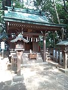
The island is uninhabited, but connected to the mainland by a 400 m long footbridge. On the island is the Yaotomi shrine ( 八百 富 神社 , Yaotomi-jinja ) dedicated to the water goddess Benten , which is said to have been founded in 1181 by Fujiwara no Toshinari . This includes four other shrines in honor of other kami - the Uga shrine ( 宇 賀 神社 , Uga-jinja ) for the food god Ukanomitama , the Hachidaiyū shrine ( 八大 龍 神社 , Hachidaiyū-jinja) for the sea god Ryūjin , Daikoku shrine ( 大 黒 神社 , Daikoku-jinja ) for the god of agriculture and medicine Ōkuninushi and the Chitose shrine ( 千 歳 神社 , Chitose-jinja ) in which Fujiwara no Toshinari itself is deified.
The shrine complex is located in the middle of a thicket, which is characterized by the tree species Machilus thunbergii , Ilex integra , Daphniphyllum teijsmannii and Cinnamomum tenuifolium or a total of 238 plant species. In addition, Takeshima is the northernmost habitat of the Carex matsumurae grass species in Japan. Due to this natural wealth, the island was declared a natural monument in 1930.
On the opposite bank of the river, the Gamagōri Classic Hotel in Art Deco style overlooks the island on a hill .

Takeshima bridge to the island

Prayer hall ( haiden ) of the shrine

Uga shrine

Hachidaiyu shrine
Daikoku Shrine

Gamagōri Classic Hotel


Web links
- Shrine website (Japanese)
Individual evidence
- ↑ a b 八百 富 神社 と は? . In: 国 指定 文化 財 等 デ ー タ ベ ー ス . Yaotomi Shrine. Retrieved March 22, 2015 (Japanese).