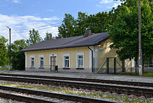
Tamsalu
| Tamsalu | |||
|
|||
| State : |
|
||
| Circle : |
|
||
| Coordinates : | 59 ° 10 ′ N , 26 ° 7 ′ E | ||
| Area : | 214.6 km² | ||
| Residents : | 4,546 (01/01/2006) | ||
| Population density : | 21 inhabitants per km² | ||
| Time zone : | EET (UTC + 2) | ||
| Website : | |||

|
|||
Tamsalu ( Eng . Tamsal ) was a rural community in the Estonian district of Lääne-Viru with an area of 214.6 km². It had 4546 inhabitants (as of 2006).
structure
In addition to the main town, the city of Tamsalu with 2572 inhabitants, the municipality included the villages of Aavere, Alupere, Araski, Assamalla, Järsi, Järvajõe, Kadapiku, Kaeva, Kerguta, Koiduküla, Koplitaguse, Kuie, Kullenga, Kursi, Lemmküla, Loketska, Naistevälja, Piisupi, Porkuni , Põdrangu, Sauvälja, Savalduma, Sääse, Türje, Uudeküla, Vadiküla, Vajangu, Vistla, Võhmetu and Võhmuta.
Culture and sights
The Porkuni lake in the municipality attracts numerous hikers, anglers and nature lovers. From 1477 onwards, the Tallinn bishop Simon von der Borch (tenure from 1477 to 1492) had Borckholm Castle built on the lake shore, of which a tower is still preserved today.
Partner municipality
Tamsalu is the partner municipality of the Rehna office in the north-west Mecklenburg district .
Web links
- Website of the municipality of Tamsalu (Estonian)
- Porkuni tourist area (Estonian)


