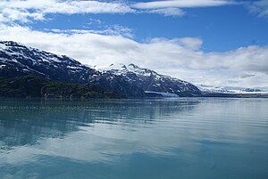
Tarr Inlet
| Tarr Inlet | ||
|---|---|---|
|
The Tarr Inlet with a view of the Margerie and Grand Pacific Glaciers |
||
| Waters | Glacier Bay | |
| Land mass | Mainland North America | |
| Geographical location | 59 ° 0 ′ N , 136 ° 58 ′ W | |
|
|
||
| width | 3 km | |
| length | 15 km | |
| Tributaries | Grand Pacific Glacier , Margerie Glacier | |
The Tarr Inlet is a fjord in the northeast of Glacier Bay National Park in the Panhandle of Alaska between Johns Hopkins Inlet and Rendu Inlet .
The inlet is about 15 km long and three kilometers wide and runs in a north-westerly direction to just about the border with British Columbia in Canada . The Grand Pacific Glacier flows into the head area of the bay, the Margerie Glacier is two kilometers further south in a side valley.
The fjord was named around 1912 by Lawrence Martin of the United States Geological Survey after Ralph Stockman Tarr, a professor of geography at Cornell University who had toured the region in 1911.
Web links
Commons : Tarr Inlet - collection of images, videos and audio files

